File:John Pinkerton. Map of Persia. 1818.H. Ghilan.jpg
Size of this preview: 621 × 599 pixels. Other resolutions: 249 × 240 pixels | 627 × 605 pixels.
Original file (627 × 605 pixels, file size: 127 KB, MIME type: image/jpeg)
Captions
Captions
Add a one-line explanation of what this file represents
Summary edit
| Description |
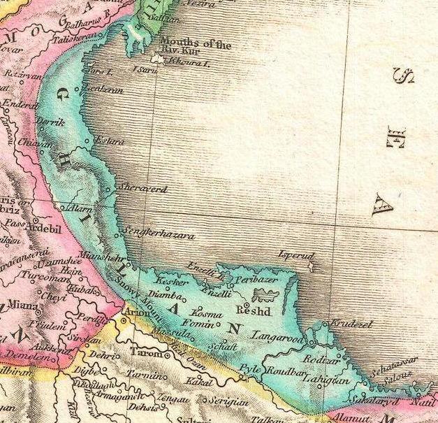
English: A rare and important 1818 map of Persia by John Pinkerton. Depicts from the Black Sea eastward as far as the Indus Valley, extends north to the Aral Sea and South to the Persian Gulf and the Arabian Sea. Includes the modern day countries of Iran and Afghanistan, as well as parts of adjacent Pakistan, Kuwait, Iraq, Turkey and Arabia. Notes both political and physical geographic elements, including rivers, mountains, under sea dangers, various tribal regions, cities, ruins, and canals. In particular, notes the ruins of both Babylon and Persepolis. Drawn by L. Herbert and engraved by Samuel Neele under the direction of John Pinkerton. The map comes from the scarce American edition of Pinkerton’s Modern Atlas, published by Thomas Dobson & Co. of Philadelphia in 1818. |
||||||||||||||||||||
| Date | (undated) | ||||||||||||||||||||
| Source |
Pinkerton, J., A Modern Atlas, from the Lates and Best Authorities, Exhibiting the Various Divisions of the World with its chief Empires, Kingdoms, and States; in Sixty Maps, carefully reduced from the Larges and Most Authentic Sources. 1818, Philadelphia, Thomas Dobson Edition.
|
||||||||||||||||||||
| Author |
|
||||||||||||||||||||
_-_Geographicus_-_Persia2-pinkerton-1818.jpg)

Licensing edit
|
This is a faithful photographic reproduction of a two-dimensional, public domain work of art. The work of art itself is in the public domain for the following reason:
The official position taken by the Wikimedia Foundation is that "faithful reproductions of two-dimensional public domain works of art are public domain".
This photographic reproduction is therefore also considered to be in the public domain in the United States. In other jurisdictions, re-use of this content may be restricted; see Reuse of PD-Art photographs for details. | ||||
File history
Click on a date/time to view the file as it appeared at that time.
| Date/Time | Thumbnail | Dimensions | User | Comment | |
|---|---|---|---|---|---|
| current | 23:16, 4 May 2011 | | 627 × 605 (127 KB) | Geagea (talk | contribs) | == {{int:filedesc}} == {{Information |Description={{en|1=A rare and important 1818 map of Persia by John Pinkerton. Depicts from the Black Sea eastward as far as the Indus Valley, extends north to the Aral Sea and South to the Persian Gulf and the Arab |
You cannot overwrite this file.
File usage on Commons
The following 2 pages use this file:
.jpg)
File usage on other wikis
The following other wikis use this file:
- Usage on de.wikivoyage.org
- Usage on fa.wikipedia.org
- Usage on glk.wikipedia.org