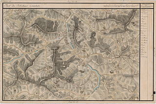
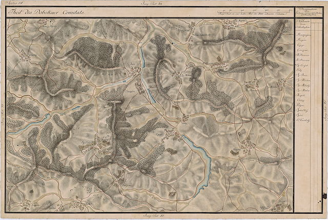
File:Josephinische Landaufnahme pg074.jpg

Size of this preview: 800 × 538 pixels. Other resolutions: 320 × 215 pixels | 640 × 430 pixels | 1,024 × 688 pixels | 1,280 × 860 pixels | 2,560 × 1,720 pixels | 8,898 × 5,980 pixels.
Original file (8,898 × 5,980 pixels, file size: 26.15 MB, MIME type: image/jpeg)
Captions
Captions
Add a one-line explanation of what this file represents
| Warning | The original file is very high-resolution. It might not load properly or could cause your browser to freeze when opened at full size. |
|---|
| Name shown on the map Nume din hartă |
Administrative unit Unitate administrativă |
Romanian name Numele românesc |
Hungarian name Numele unguresc |
German name Numele german |
Country today Ţara de astăzi |
|---|---|---|---|---|---|
| Boncz Nyires | Doboka megye Komitat Szolnok-Doboka Comitatul Dăbâca |
Bonţ | Boncnyíres | Romania | |
| Székolaj | Doboka megye | Săcălaia | Kisszék | Romania | |
| Oláh Vásárhely | Doboka megye | Târguşor | Kékesvásárhely | Romania | |
| Sz: Márton | Doboka megye | Sânmărtin | Szépkenyerűszentmárton | Romania | |
| Sz: Miklos | Doboka megye | Sânnicoară | Aranyosszentmiklós | Nikelsdorf | Romania |
| K: Devecser | Doboka megye | Diviciorii Mici | Kisdevecser | Klein Däwäts | Romania |
| N: Devecser | Doboka megye | Diviciorii Mari | Nagydevecser | Gross Däwäts | Romania |
| Sz: Mihaly | Doboka megye | Măhal | Mohaly | Romania | |
| Sz: Iván | Doboka megye | Sântioana | Vasasszentiván | Romania | |
| Császári | Doboka megye | Cesariu | Császári | Kaisersdorf | Romania |
| Göötz | Doboka megye | Ghiolţ | Göc | Götz | Romania |
| Czege | Doboka megye | Ţaga | Cege | Zegen | Romania |
| Noszály | Doboka megye | Nâsal | Noszoly | Spanndorf | Romania |
| Sz: Enyed | Doboka megye | Sântejude | Vasasszentegyed | Romania | |
| Bógáts | Doboka megye | Băgaciu | Kisbogács | Disteldorf | Romania |
| Szává | Doboka megye | Sava | Mezőszava | Romania | |
| Ombotz | Doboka megye | Mureşenii de Câmpie | Omboztelke | Romania | |
| Pulyon | Doboka megye | Puini | Kispulyon | Romania | |
| Búza | Doboka megye | Búza | Búza | Besotten | Romania |
Summary
edit
| Description |
English: Grand Duchy of Transylvania, 1769-1773. Josephinische Landaufnahme pg.074 Română: Harta Iosefină a Transilvaniei, 1769-1773. Josephinische Landaufnahme pg.074 |
||||
| Date | between 1769 and 1773 | ||||
| Source | Österreichisches Staatsarchiv, Kriegsarchiv, B IX 715: Original-Aufnahmskarte des Grossfürtenthums Siebenbürgen. Geometrisch aufgenommen und bearbeitet in den Jahren 1769 bis 1773 unter der Direction des Obristen von Fabris, theils durch Officiere des grossen Feld-Generalstabes, theils auch von verschiedenen aus dem in Siebenbürgen bequartierten Regimentern zu diesem Geschäfte beigezogenen Individuen | ||||
| Author | Historische Militärkarte der österreichisch-ungarischen Monarchie | ||||
| Permission (Reusing this file) |
|
||||
Clickable Map of the Grand Duchy of Transylvania
edit
File history
Click on a date/time to view the file as it appeared at that time.
| Date/Time | Thumbnail | Dimensions | User | Comment | |
|---|---|---|---|---|---|
| current | 09:55, 4 December 2009 | | 8,898 × 5,980 (26.15 MB) | Asybaris01 (talk | contribs) | good rezolution |
| 06:36, 23 October 2009 |  | 5,784 × 3,887 (18.13 MB) | Asybaris01 (talk | contribs) | {{Information |Description={{ro|1=Josephinische Landaufnahme pg74}} |Source=Josephinische Landaufnahme pg74 |Author=Asybaris01 |Date=2009/10/23 |Permission= |other_versions= }} |
You cannot overwrite this file.
File usage on Commons
There are no pages that use this file.
File usage on other wikis
The following other wikis use this file:
- Usage on arz.wikipedia.org
- Usage on hu.wikipedia.org
- Usage on ro.wikipedia.org
- Comuna Țaga, Cluj
- Comuna Buza, Cluj
- Băgaciu, Cluj
- Bonț, Cluj
- Diviciorii Mari, Cluj
- Diviciorii Mici, Cluj
- Măhal, Cluj
- Mureșenii de Câmpie, Cluj
- Năsal, Cluj
- Puini, Cluj
- Sava, Cluj
- Săcălaia, Cluj
- Sânmărtin (Chinteni), Cluj
- Sântejude, Cluj
- Sântioana, Cluj
- Târgușor, Cluj
- Sânnicoară, Bistrița-Năsăud
- Buza, Cluj