File:Juist Kante Bill.jpg

Size of this preview: 800 × 427 pixels. Other resolutions: 320 × 171 pixels | 640 × 341 pixels | 1,024 × 546 pixels | 1,671 × 891 pixels.
Original file (1,671 × 891 pixels, file size: 158 KB, MIME type: image/jpeg)
Captions
Captions
Add a one-line explanation of what this file represents
Summary edit
| Description |
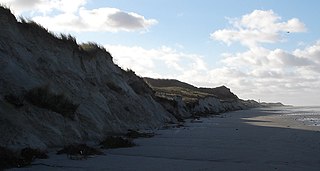
English: Edge of dunes on the western beach of Juist island. Every year the sea erodes about 5 meters off the dunes.
Deutsch: Die Abbruchkante am westlichen Strand der Insel Juist Infolge der Erosion verliert die Insel zwischen Hammersee und Bill jeden Winter etwa 5m Düne. |
| Date | |
| Source | Own work |
| Author | Arne Hückelheim |
| Permission (Reusing this file) |
| Camera location | | View this and other nearby images on: OpenStreetMap |
|---|
Licensing edit
I, the copyright holder of this work, hereby publish it under the following licenses:
This file is licensed under the Creative Commons Attribution-Share Alike 3.0 Unported license.
- You are free:
- to share – to copy, distribute and transmit the work
- to remix – to adapt the work
- Under the following conditions:
- attribution – You must give appropriate credit, provide a link to the license, and indicate if changes were made. You may do so in any reasonable manner, but not in any way that suggests the licensor endorses you or your use.
- share alike – If you remix, transform, or build upon the material, you must distribute your contributions under the same or compatible license as the original.
This file is licensed under the Creative Commons Attribution-Share Alike 2.0 Germany license.
- You are free:
- to share – to copy, distribute and transmit the work
- to remix – to adapt the work
- Under the following conditions:
- attribution – You must give appropriate credit, provide a link to the license, and indicate if changes were made. You may do so in any reasonable manner, but not in any way that suggests the licensor endorses you or your use.
- share alike – If you remix, transform, or build upon the material, you must distribute your contributions under the same or compatible license as the original.


|
Permission is granted to copy, distribute and/or modify this document under the terms of the GNU Free Documentation License, Version 1.2 or any later version published by the Free Software Foundation; with no Invariant Sections, no Front-Cover Texts, and no Back-Cover Texts. A copy of the license is included in the section entitled GNU Free Documentation License. |
You may select the license of your choice.
File history
Click on a date/time to view the file as it appeared at that time.
| Date/Time | Thumbnail | Dimensions | User | Comment | |
|---|---|---|---|---|---|
| current | 03:22, 30 August 2010 | | 1,671 × 891 (158 KB) | Knipptang (talk | contribs) | == Summary == {{Information |Description={{en|1=Edge of dunes on the western beach of Juist island. Every year the sea erodes about 5 meters off the dunes. }} {{de|1=Die Abbruchkante am westlichen Strand der Insel Juist In |
You cannot overwrite this file.
File usage on Commons
There are no pages that use this file.
File usage on other wikis
The following other wikis use this file:
- Usage on de.wikipedia.org