File:Jutrosin (gmina) location map.png
Size of this preview: 485 × 600 pixels. Other resolutions: 194 × 240 pixels | 559 × 691 pixels.
Original file (559 × 691 pixels, file size: 63 KB, MIME type: image/png)
Captions
Captions
Add a one-line explanation of what this file represents
| Description |
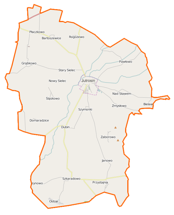
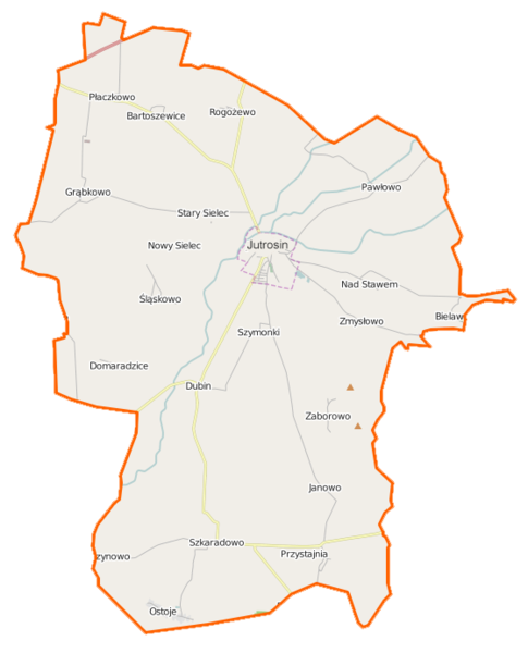
Polski: Mapa gminy Jutrosin, Polska
English: Map of Gmina Jutrosin, Poland |
|||||||||
| Date | ||||||||||
| Source | You may find a page on the OpenStreetMap wiki page for Jutrosin (gmina) | |||||||||
| Creator |
OpenStreetMap contributors OpenStreetMap contributors |
|||||||||
| Permission (Reusing this file) |
OpenStreetMap data is available under the Open Database License (details). Map tiles are licensed under the Creative Commons Attribution-ShareAlike 2.0 license (CC-BY-SA 2.0).
This file is licensed under the Creative Commons Attribution-Share Alike 2.0 Generic license.
|
|||||||||
| Geotemporal data | ||||||||||
| Bounding box |
|
|||||||||
| Georeferencing | If inappropriate please set warp_status = skip to hide. | |||||||||
File history
Click on a date/time to view the file as it appeared at that time.
| Date/Time | Thumbnail | Dimensions | User | Comment | |
|---|---|---|---|---|---|
| current | 20:14, 27 December 2014 | | 559 × 691 (63 KB) | VanWiel (talk | contribs) | {{OpenStreetMap | name = Jutrosin (gmina) | location = Jutrosin (gmina) | description = {{pl|Mapa gminy Jutrosin, Polska}} {{en|Map of Gmina Jutrosin, Poland}} | top = 51.7081 | bottom = 51.5609 | l... |
You cannot overwrite this file.
File usage on Commons
There are no pages that use this file.
File usage on other wikis
The following other wikis use this file:
- Usage on de.wikipedia.org
- Usage on fr.wikipedia.org
- Usage on pl.wikipedia.org
- Jutrosin
- Jutrosin (gmina)
- Bartoszewice (województwo wielkopolskie)
- Dubin
- Nad Stawem
- Nowy Sielec
- Rogożewo
- Szkaradowo
- Szymonki
- Stary Sielec
- Śląskowo
- Domaradzice (województwo wielkopolskie)
- Grąbkowo (województwo wielkopolskie)
- Jeziora (województwo wielkopolskie)
- Ostoje (województwo wielkopolskie)
- Bielawy (powiat rawicki)
- Janowo (powiat rawicki)
- Pawłowo (powiat rawicki)
- Płaczkowo (powiat rawicki)
- Zaborowo (powiat rawicki)
- Zmysłowo (gmina Jutrosin)
- Dębina (Śląskowo)
- Bonowo
- Domaradzice-Borek
- Katarzynowo (Szkaradowo)
- Ochłoda
- Piskornia (Pawłowo)
- Stasin (województwo wielkopolskie)
- Wielki Bór (osada w województwie wielkopolskim)
- Zygmuntowo (powiat rawicki)
- Żydowski Bród
- Jutrosin (przystanek kolejowy)
- Parafia św. Elżbiety w Jutrosinie
- Cmentarz żydowski w Jutrosinie
- Parafia św. Mikołaja Biskupa w Dubinie
- Kościół św. Elżbiety w Jutrosinie
- Kościół św. Mikołaja Biskupa w Dubinie
- Wielki Bór (osada leśna w województwie wielkopolskim)
- Żbiki (powiat rawicki)
- Kościół św. Marcina w Szkaradowie
- Muzeum Ziemi Jutrosińskiej w Jutrosinie
- Ratusz w Jutrosinie
- Moduł:Mapa/dane/Jutrosin
- Moduł:Mapa/dane/Jutrosin (gmina)
- Parafia św. Marcina w Szkaradowie
- Kościół św. Krzyża w Jutrosinie
- Kościół poewangelicki w Jutrosinie
- Kościół Przemienienia Pańskiego w Domaradzicach-Borku
View more global usage of this file.
_location_map.png)
_location_map.png&oldid=519968746)