File:Köln Neumarkt – Kugelpanorama aus 400 Metern Höhe (April 2020).jpg

Size of this preview: 800 × 400 pixels. Other resolutions: 320 × 160 pixels | 640 × 320 pixels | 1,024 × 512 pixels | 1,280 × 640 pixels | 2,560 × 1,280 pixels | 8,192 × 4,096 pixels.
Original file (8,192 × 4,096 pixels, file size: 8.45 MB, MIME type: image/jpeg)
Captions
Captions
Add a one-line explanation of what this file represents
Summary
edit.jpg&action=edit§ion=1)
| 360° | View in 360° panoramic viewer
|
|---|
.jpg)
| Description |
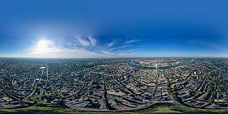
Deutsch: Der Kölner Neumarkt ist der zentrale Platz der Stadt. In diesem Rundum-Panorama ist die ganze Stadt zu sehen, mit dem Rhein, dem Dom, dem Aachener Weiher und ganz im Südem dem Deutschlandfunk.
Der Platz wirkt an diesem Donnerstag Spätnachmittag wie verlassen. Das liegt an der damals herrschenden COVID-19-Pandemie. Die Höhe von 400 m beruhte auf Ausnahmegenehmigungen der Stadt Köln, der Bezirksregierung Düsseldorf und der Deutschen Flugsicherung. |
| Date | |
| Source | Own work |
| Author | Maximilian Schönherr |
| Camera location | | View this and other nearby images on: OpenStreetMap |
|---|
.jpg¶ms=050.936104_N_0006.947400_E_globe:Earth_type:camera__&language=en)
Licensing
edit.jpg&action=edit§ion=2)
I, the copyright holder of this work, hereby publish it under the following license:
This file is licensed under the Creative Commons Attribution-Share Alike 4.0 International license.
- You are free:
- to share – to copy, distribute and transmit the work
- to remix – to adapt the work
- Under the following conditions:
- attribution – You must give appropriate credit, provide a link to the license, and indicate if changes were made. You may do so in any reasonable manner, but not in any way that suggests the licensor endorses you or your use.
- share alike – If you remix, transform, or build upon the material, you must distribute your contributions under the same or compatible license as the original.
File history
Click on a date/time to view the file as it appeared at that time.
| Date/Time | Thumbnail | Dimensions | User | Comment | |
|---|---|---|---|---|---|
| current | 19:58, 23 April 2020 | | 8,192 × 4,096 (8.45 MB) | Maximilian Schönherr (talk | contribs) | Uploaded own work with UploadWizard |
You cannot overwrite this file.
File usage on Commons
There are no pages that use this file.
.jpg&oldid=847097404)