File:Köppen-Geiger Climate Classification Map (2071–2100) no borders.png

Size of this preview: 800 × 400 pixels. Other resolutions: 320 × 160 pixels | 640 × 320 pixels | 1,024 × 512 pixels | 1,280 × 640 pixels | 2,560 × 1,280 pixels | 4,320 × 2,160 pixels.
Original file (4,320 × 2,160 pixels, file size: 267 KB, MIME type: image/png)
Captions
Captions
Add a one-line explanation of what this file represents
Summary
edit| Description |
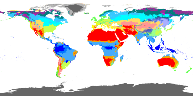
English: An equirectangular world map showing predicted Köppen-Geiger climate classifications for the years 2071 to 2100.
|
||||||||||||||||||||||||||||||||||||
| Date | |||||||||||||||||||||||||||||||||||||
| Source | |||||||||||||||||||||||||||||||||||||
| Author | Beck, H.E., Zimmermann, N. E., McVicar, T. R., Vergopolan, N., Berg, A., & Wood, E. F. | ||||||||||||||||||||||||||||||||||||
| Other versions |
[] SVGedit
(The SVG versions are huge due to overly detailed political borders. The actual data are in the raster.) PNGedit
|
||||||||||||||||||||||||||||||||||||

.png)

_no_borders.png)
_no_borders.png)
_no_borders.png&action=edit§ion=1)
Licensing
edit_no_borders.png&action=edit§ion=2)
This file is licensed under the Creative Commons Attribution-Share Alike 4.0 International license.
- You are free:
- to share – to copy, distribute and transmit the work
- to remix – to adapt the work
- Under the following conditions:
- attribution – You must give appropriate credit, provide a link to the license, and indicate if changes were made. You may do so in any reasonable manner, but not in any way that suggests the licensor endorses you or your use.
- share alike – If you remix, transform, or build upon the material, you must distribute your contributions under the same or compatible license as the original.
File history
Click on a date/time to view the file as it appeared at that time.
| Date/Time | Thumbnail | Dimensions | User | Comment | |
|---|---|---|---|---|---|
| current | 14:43, 4 March 2019 | | 4,320 × 2,160 (267 KB) | TilmannR (talk | contribs) | User created page with UploadWizard |
You cannot overwrite this file.
File usage on Commons
The following 7 pages use this file:
- File:Koppen-Geiger Map World future.svg
- File:Koppen-Geiger Map World present.svg
- File:Köppen-Geiger Climate Classification Map.png
- File:Köppen-Geiger Climate Classification Map (1980–2016) no borders.png
- File:Köppen-Geiger Climate Classification Map (2071–2100) no borders.png
- File:Köppen-Geiger climate classification (1980-2016).png
- Template:Other versions/Köppen-Geiger climate classification world map
File usage on other wikis
The following other wikis use this file:
- Usage on es.wikipedia.org
- Usage on ro.wikipedia.org
- Usage on sv.wikipedia.org
_no_borders.png&oldid=775058003)