File:K0nigl+herzoglPreussen.png
Original file (1,036 × 756 pixels, file size: 42 KB, MIME type: image/png)
Captions
Captions
Summary edit
| Description |
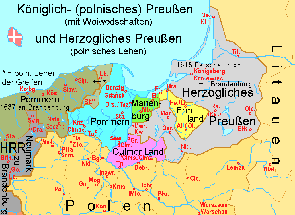
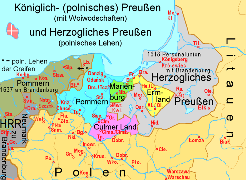
Prussia from 1466 to 1772:
Abbreviations/Abkürzungen: Al./Ol. = Allenstein/Olsztyn; Bg. = Bydgoszcz/Bromberg; Biał. = Białystok; Bra. = Braniewo/Braunsberg; Brln. = Barlinek/Berlinchen; Bt. = Bytów/Bütow; Cie. = Ciechanów; Clm. = Culm/Chełmno; Clms./Cłmż. = Culmsee/Chełmża; Dobr. (nördl.) = Golub-Dobrzyń/Gollup; Dobr. (südl.) = Dobrzyń nad Wisłą; Dra. = Drawsko Pomorskie/Dramburg; El. = Elbląg/Elbing; Fla./Zło. = Złotów/Flatow; Fr. = Frombork/Frauenburg; Gn. = Gniezno/Gnesen; Go./La. = Gorzów Wielkopolski/Landsberg an der Warthe; Gr. = Grudziądz/Graudenz; He./Li. = Heilsberg/Lidzbark Warmiński; Inowr. = Inowrocław/Hohensalza; Knz./Chnce. = Chojnice/Konitz; Kobg. = Kolberg/Kołobrzeg; Kös. = Köslin/Koszalin; Kon. = Konin; Krus. = Kruszwica/Kruschwitz; Mb. = Malbork/Marienburg; Me. = Memel/Klaipėda; Mog. = Mogilno; Mor. = Morąg/Mohrungen; Mwr./Kwi. = Marienwerder/Kwidzyn; Nid. = Nidzica/Neidenburg; Nkl. = Nakło nad Notecią/Nakel an der Netze; Nstn./Szczk. = Szczecinek/Neustettin; Ole. = Olecko/Marggrabowa; Osr. = Ostróda/Osterode; Piła/Snm. = Piła/Schneidemühl; Pło. = Płock; Po. = Poznań/Posen; Ra. = Rastenburg/Kętrzyn; Slaw. = Sławno/Schlawe; Slp. = Słupsk/Stolp; Sta. (südl. Danzig)= Starogard Gdański/Preußisch Stargard; Sta. (westl. Kartenrand) = Stargrad/Stargard in Pommern; Swe. = Świecie/Schwetz an der Weichsel; Swn./Svn. = Świdwin/Schivelbein; Drs./Tcz. = Tczew/Dirschau; Til. = Tilsit/Советск; Tn. = Toruń/Thorn; Tu. = Tuchola/Tuchel; Wał. = Wałcz/Deutsch Krone; Wło. = Włocławek |
||
| Date | + -10-01 | ||
| Source | Own work | ||
| Author | Ulamm | ||
| Permission (Reusing this file) |
|
||
| Other versions |
|


File history
Click on a date/time to view the file as it appeared at that time.
| Date/Time | Thumbnail | Dimensions | User | Comment | |
|---|---|---|---|---|---|
| current | 00:18, 24 June 2018 | | 1,036 × 756 (42 KB) | Ulamm (talk | contribs) | one more Dobrzyn |
| 12:13, 11 June 2018 |  | 1,036 × 756 (42 KB) | Ulamm (talk | contribs) | position of Olsztyn corrected | |
| 21:42, 9 June 2018 |  | 1,036 × 756 (41 KB) | Ulamm (talk | contribs) | border between Griffin Pomerania & Neumark corrected, some more places with acronyms, some more rivers drawn | |
| 23:32, 16 February 2009 |  | 1,036 × 756 (30 KB) | Disposable.Heroes (talk | contribs) | pngcrush | |
| 13:52, 11 January 2008 |  | 1,036 × 756 (33 KB) | Ulamm (talk | contribs) | ||
| 10:14, 1 October 2007 |  | 1,036 × 756 (32 KB) | Ulamm (talk | contribs) | |Description=Prussia from 1466 to 1772:<br> Coloured: The voyewod-districts of Royal (i.e. Polish) Prussia, Light gray: The Dukedom of Prussia (up to 1525 state of the Teutonic Order, since 1701 royal province of the Kingdom of Prussia) |Source=own work | | |
| 19:54, 30 September 2007 |  | 1,036 × 756 (31 KB) | Ulamm (talk | contribs) | {{Information |Description=Prussia from 1466 to 1772:<br> Coloured: The voyewod-districts of Royal (i.e. Polish) Prussia, Light gray: The Dukedom of Prussia (up to 1525 state of the Teutonic Order, since 1701 royal province of the Kingdom of Prussia) |Sou |
You cannot overwrite this file.
File usage on Commons
The following 4 pages use this file:
File usage on other wikis
The following other wikis use this file:
- Usage on bg.wikipedia.org
- Usage on ca.wikipedia.org
- Usage on da.wikipedia.org
- Usage on de.wikipedia.org
- 1466
- Provinz Westpreußen
- Pommerellen
- Union von Lublin
- Zweiter Frieden von Thorn
- Deutschordensstaat
- Preußischer Bund
- Königlich Preußen
- Preußen (historische Landschaft)
- Dreizehnjähriger Krieg
- Diskussion:Preußen (historische Landschaft)
- Wikipedia:Kartenwerkstatt/Archiv/2008-01
- Fürstbistum Ermland
- Achatius von Zehmen
- Liste historischer Regionen Polens
- Fabian I. von Zehmen
- Fabian III. von Zehmen
- Achaz II. von Zehmen
- Fabian II. von Zehmen
- Liste der Backsteinbauwerke der Gotik in Polen
- Benutzer:Ulamm/Backsteinbauwerke der Gotik in Polen und der Ukraine
- Usage on el.wikipedia.org
- Usage on et.wikipedia.org
- Usage on fr.wikipedia.org
- Usage on hu.wikipedia.org
- Usage on ja.wikipedia.org
- Usage on lv.wikipedia.org
- Usage on nl.wikipedia.org
- Usage on vls.wikipedia.org