File:KAARTEN SGD - Kaart van de spoorweglijnen van de diverse maatschappijen op Oost Java.jpeg

Size of this preview: 667 × 600 pixels. Other resolutions: 267 × 240 pixels | 534 × 480 pixels | 854 × 768 pixels | 1,139 × 1,024 pixels | 1,831 × 1,646 pixels.
Original file (1,831 × 1,646 pixels, file size: 265 KB, MIME type: image/jpeg)
Captions
Captions
Add a one-line explanation of what this file represents
Summary edit
| Title |
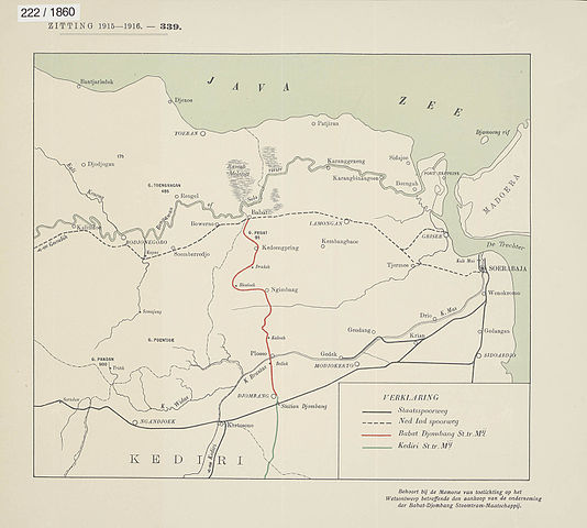
KAARTEN SGD - Kaart van de spoorweglijnen van de diverse maatschappijen op Oost Java |
||||||||||||||||||||||||||
| Description |
Behoort bij de Memorie van Toelichting op het Wetsontwerp betreffende den aankoop van de onderneming der Babat-Djombang Stoomtram-Maatschappij. De lijn der Babat-Djombang Stoomtram Maatschappij brengt het gewest Kidiri, dat voor den afvoer van zijne voortbrengselen naar Soerabaja natuurlijkerwijs op de staatsspoorlijn Kertosono-Soerabaja is aangewezen, in rechtstreeksche verbinding met de lijn Goendih-Soerabaja van de Nederlandsch-Indische Spoorweg Maatschappij. Dientengevolge dreigt het gevaar, dat laatstgenoemde maatschappij in samenwerking met de Babat-Djombang Stoomtram Maatschappij, het goederenvervoer uit het Kedirische naar Soerabaja door aanbieding van bijzondere tarieven geheel of grootendeels langs hare lijnen zal weten te leiden, tot schade van het bedrijf der Staatsspoorwegen. Door aankoop van delijn Babat-Djombang kan de mogelijke schade aan de Staatsspoorwegen worden afgewend |
||||||||||||||||||||||||||
| Date | |||||||||||||||||||||||||||
| Source |
This image in context: http://www.statengeneraaldigitaal.nl/document?id=sgd:mpeg21:19151916:0001970&pagina=3;
|
||||||||||||||||||||||||||
| Creator |
English: The individual creators of this map are unknown, it was commissioned by the House of Representatives of the Netherlands.
Nederlands: De precieze makers van deze kaart zijn niet bekend, hij werd in opdracht van de Tweede Kamer der Staten-Generaal gemaakt. |
||||||||||||||||||||||||||
| Permission (Reusing this file) |
|
||||||||||||||||||||||||||
| Geotemporal data | |||||||||||||||||||||||||||
| Date depicted | |||||||||||||||||||||||||||
| Map location | Oost-Java | ||||||||||||||||||||||||||
| Scale | ca. 1:500.000 | ||||||||||||||||||||||||||
| Bounding box |
|
||||||||||||||||||||||||||
| Georeferencing | If inappropriate please set warp_status = skip to hide. | ||||||||||||||||||||||||||
| Bibliographic data | |||||||||||||||||||||||||||
| Publisher |
This map was commissioned and published by the
|
||||||||||||||||||||||||||
| Archival data | |||||||||||||||||||||||||||
| Collection |
This map was digitized by the
|
||||||||||||||||||||||||||
| Notes |
Nederlands: eigendom en gebruiksrecht onroerend goed, spoorwegnet |
||||||||||||||||||||||||||


File history
Click on a date/time to view the file as it appeared at that time.
| Date/Time | Thumbnail | Dimensions | User | Comment | |
|---|---|---|---|---|---|
| current | 05:13, 15 November 2015 | | 1,831 × 1,646 (265 KB) | OlafJanssen (talk | contribs) | GWToolset: Creating mediafile for OlafJanssen. |
You cannot overwrite this file.
File usage on Commons
There are no pages that use this file.
File usage on other wikis
The following other wikis use this file:
- Usage on id.wikipedia.org