File:KAUW RNAV GPS 31 Chart.svg

Size of this PNG preview of this SVG file: 390 × 599 pixels. Other resolutions: 156 × 240 pixels | 313 × 480 pixels | 500 × 768 pixels | 667 × 1,024 pixels | 1,334 × 2,048 pixels | 516 × 792 pixels.
Original file (SVG file, nominally 516 × 792 pixels, file size: 937 KB)
Captions
Captions
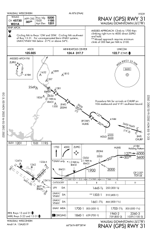
GPS Approach Chart for Runway 31 at KAUW Airport
Summary edit
| Description |
English: GPS Approach Chart for Runway 31 at Wausau Downtown Airport in Marathon County, Wisconsin, U.S.
Deutsch: GPS-Anflugkarte für Piste 31 am Wausau Downtown Airport in Marathon County, Wisconsin, USA
Español: Gráfico de aproximación GPS para la pista 31 en el aeropuerto del centro de Wausau en el condado de Marathon, Wisconsin, EE. UU. |
| Date | |
| Source | https://aeronav.faa.gov/d-tpp/2211/00874R31.PDF |
| Author | FAA |
| Camera location | | View this and other nearby images on: OpenStreetMap |
|---|
Licensing edit
This image or file is a work of a Federal Aviation Administration employee, taken or made as part of that person's official duties. As a work of the U.S. federal government, the image is in the public domain in the United States.
|
 |
File history
Click on a date/time to view the file as it appeared at that time.
| Date/Time | Thumbnail | Dimensions | User | Comment | |
|---|---|---|---|---|---|
| current | 02:51, 20 November 2022 | | 516 × 792 (937 KB) | KDTW Flyer (talk | contribs) | Uploaded own work with UploadWizard |
You cannot overwrite this file.
File usage on Commons
The following page uses this file:
File usage on other wikis
The following other wikis use this file:
- Usage on en.wikipedia.org