File:KKW Fukushima - Lage.png

Size of this preview: 800 × 559 pixels. Other resolutions: 320 × 223 pixels | 640 × 447 pixels | 905 × 632 pixels.
Original file (905 × 632 pixels, file size: 206 KB, MIME type: image/png)
Captions
Captions
Add a one-line explanation of what this file represents
Summary
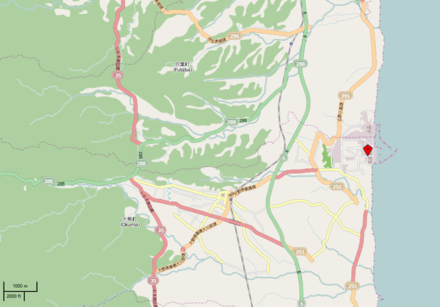
edit| Description |
Deutsch: Lage des Kernkraftwerks Fukushima I |
| Date | |
| Source | openstreetmap.org |
| Creator |
OpenStreetMap contributors OpenStreetMap contributors |
| Permission (Reusing this file) |
OpenStreetMap data and maps are licensed under the Creative Commons Attribution-ShareAlike 2.0 license (CC-BY-SA 2.0). This file is licensed under the Creative Commons Attribution-Share Alike 2.0 Generic license.
|
| Georeferencing | If inappropriate please set warp_status = skip to hide. |
| Other versions |
|

| Annotations | This image is annotated: View the annotations at Commons |
File history
Click on a date/time to view the file as it appeared at that time.
| Date/Time | Thumbnail | Dimensions | User | Comment | |
|---|---|---|---|---|---|
| current | 16:04, 12 March 2011 | | 905 × 632 (206 KB) | MartinThoma (talk | contribs) | {{Information |Description={{de|Lage des Kernkraftwerk Fukushima I}} |Source={{#if: {{{name|}}} | {{{source|See the image in its original context on the [http://wiki.openstreetmap.org/index.php/{{urlencode:{{{name}}}}} OpenStreetMap wiki page for {{{name} |
You cannot overwrite this file.
File usage on Commons
The following page uses this file:
File usage on other wikis
The following other wikis use this file:
- Usage on de.wikipedia.org