File:KLTX loop of Hurricane Ian's landfall in South Carolina.gif
No higher resolution available.
KLTX_loop_of_Hurricane_Ian's_landfall_in_South_Carolina.gif (600 × 550 pixels, file size: 631 KB, MIME type: image/gif, looped, 10 frames, 3.3 s)
Captions
Captions
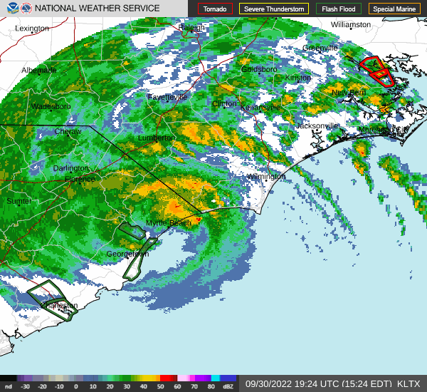
Hurricane Ian at its landfall near Georgetown, South Carolina on September 30, 2022.
Summary
edit
| Description |
English: Hurricane Ian making its final landfall near Georgetown, South Carolina on September 30, 2022. At landfall, the storm was a category 1 hurricane with sustained winds of 85 mph and a minimum barometric pressure of 977 mb. |
| Date | |
| Source | https://www.weather.gov/ilm/ |
| Author | NWS Forecast Office Wilmington, NC |
Licensing
edit
This image is in the public domain because it is from one or more of the U.S. government’s 159 NEXRAD radars, which are jointly owned and operated by the National Weather Service (NWS), an agency of the National Oceanic and Atmospheric Administration (NOAA) within the United States Department of Commerce, the Federal Aviation Administration (FAA) within the Department of Transportation, and the U.S. Air Force within the Department of Defense.
Thus all NEXRAD images are public domain.
|
  |
File history
Click on a date/time to view the file as it appeared at that time.
| Date/Time | Thumbnail | Dimensions | User | Comment | |
|---|---|---|---|---|---|
| current | 19:14, 11 October 2022 | | 600 × 550 (631 KB) | ChessEric (talk | contribs) | Uploaded a work by NWS Forecast Office Wilmington, NC from https://www.weather.gov/ilm/ with UploadWizard |
You cannot overwrite this file.
File usage on Commons
There are no pages that use this file.
File usage on other wikis
The following other wikis use this file:
- Usage on en.wikipedia.org