File:KSC-03PD-3300.jpg

Size of this preview: 450 × 600 pixels. Other resolutions: 180 × 240 pixels | 360 × 480 pixels | 576 × 768 pixels | 768 × 1,024 pixels | 2,250 × 3,000 pixels.
Original file (2,250 × 3,000 pixels, file size: 589 KB, MIME type: image/jpeg)
Captions
Captions
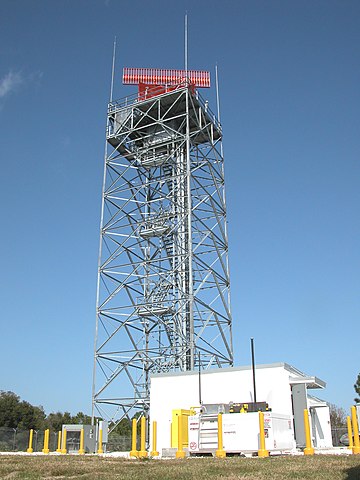
Air Traffic Control radar, Shiloh, Kennedy Space Center
Summary
edit
| Description |
English: KENNEDY SPACE CENTER, FLA. An Air Traffic Control radar has been constructed at Shiloh for the NASA control tower at the Shuttle Landing Facility. It will be used by NASA and the Eastern Range for surveillance of controlled air space in Kennedy Space Center and Cape Canaveral Air Force Station restricted areas. Shiloh is on the northern end of Merritt Island. Photos By: National Aeronautics and Space Administration |
| Date | |
| Source |
https://science.ksc.nasa.gov/gallery/photos/2003/captions/KSC-03PD-3300.html |
| Author | NASA Kennedy Space Center |
| Camera location | | View this and other nearby images on: OpenStreetMap |
|---|
Licensing
edit
| This file is in the public domain in the United States because it was solely created by NASA. NASA copyright policy states that "NASA material is not protected by copyright unless noted". (See Template:PD-USGov, NASA copyright policy page or JPL Image Use Policy.) | ||
 |
Warnings:
|
File history
Click on a date/time to view the file as it appeared at that time.
| Date/Time | Thumbnail | Dimensions | User | Comment | |
|---|---|---|---|---|---|
| current | 07:36, 8 November 2020 | | 2,250 × 3,000 (589 KB) | Sv1xv (talk | contribs) | Uploaded a work by NASA Kennedy Space Center from https://science.ksc.nasa.gov/gallery/photos/2003/captions/KSC-03PD-3300.html <BR> http://images.ksc.nasa.gov/photos/2003/high/KSC-03PD-3300.jpg with UploadWizard |
You cannot overwrite this file.
File usage on Commons
The following page uses this file: