File:Kaart de bevrijding van Oost- en Noord-Nederland.png

Size of this preview: 397 × 600 pixels. Other resolutions: 159 × 240 pixels | 318 × 480 pixels | 819 × 1,237 pixels.
Original file (819 × 1,237 pixels, file size: 373 KB, MIME type: image/png)
Captions
Captions
Add a one-line explanation of what this file represents
Summary
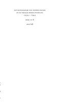
edit| Description |
Nederlands: Kaart met een overzicht van de bevrijding van Oost- en Noord-Nederland |
| Date | |
| Source | Koninkrijk der Nederlanden in de Tweede Wereldoorlog, deel 10b, 1e helft, pagina 1138 |
| Author | P. Compaan |
| Permission (Reusing this file) |
This file is licensed under the Creative Commons Attribution 3.0 Unported license.
|
| Other versions |
File history
Click on a date/time to view the file as it appeared at that time.
| Date/Time | Thumbnail | Dimensions | User | Comment | |
|---|---|---|---|---|---|
| current | 19:08, 7 May 2015 | | 819 × 1,237 (373 KB) | Hannolans (talk | contribs) | cropped |
| 19:05, 7 May 2015 |  | 1,239 × 1,754 (444 KB) | Hannolans (talk | contribs) | User created page with UploadWizard |
You cannot overwrite this file.
File usage on Commons
There are no pages that use this file.
File usage on other wikis
The following other wikis use this file: