File:Kaart van Maastricht door Larcher d'Aubencourt, 1748, detail omgeving Duitse Poort, Wyck.jpg

Size of this preview: 800 × 582 pixels. Other resolutions: 320 × 233 pixels | 640 × 466 pixels | 904 × 658 pixels.
Original file (904 × 658 pixels, file size: 263 KB, MIME type: image/jpeg)
Captions
Captions
Add a one-line explanation of what this file represents
Summary edit
| Description |
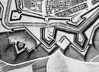
English: Maastricht, the Netherlands. Detail of a map showing a part of the city in 1749. The map by French military engineer Jean-Baptiste Larcher d'Aubencourt was used to built the Maquette of Maastricht (1752), now in the Musée de Beaux Arts in Lille, France. Here the area around Duitse Poort (German or Aachen Gate, r) in Wyck with ravelin De Raaf (116), bastions Parma (109) and Galgen (Gallows, 111) and lunettes Valkenburg (117) and Eghien (116). |
| Date | |
| Source | http://beeldbank.cultureelerfgoed.nl/alle-afbeeldingen/weergave/search/layout/result/indeling/detail/start/2?searchfield=Larcher+d%5C%5C%5C%27Aubancourt |
| Author | Jean-Baptiste Larcher d'Aubencourt, 1749 |
Licensing edit
|
This work is in the public domain in its country of origin and other countries and areas where the copyright term is the author's life plus 100 years or fewer. | |
| This file has been identified as being free of known restrictions under copyright law, including all related and neighboring rights. | |
File history
Click on a date/time to view the file as it appeared at that time.
| Date/Time | Thumbnail | Dimensions | User | Comment | |
|---|---|---|---|---|---|
| current | 23:56, 10 January 2015 | | 904 × 658 (263 KB) | Kleon3 (talk | contribs) | User created page with UploadWizard |
You cannot overwrite this file.
File usage on Commons
There are no pages that use this file.
File usage on other wikis
The following other wikis use this file:
- Usage on nl.wikipedia.org