File:Kaart van de Nederlandse Antillen Generale verzamelkaart der Nederlandsche Westindische Bezittingen (titel op object), NG-1064-10 (cropped2).jpg

Size of this preview: 453 × 599 pixels. Other resolutions: 181 × 240 pixels | 363 × 480 pixels | 581 × 768 pixels | 1,137 × 1,503 pixels.
Original file (1,137 × 1,503 pixels, file size: 189 KB, MIME type: image/jpeg)
Captions
Captions
Add a one-line explanation of what this file represents
Summary
edit| Description |
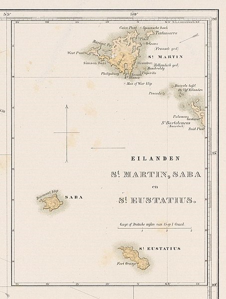
Nederlands: Identificatie Titel(s): Kaart van de Nederlandse Antillen. Generale verzamelkaart der Nederlandsche Westindische Bezittingen (titel op object) Objecttype: prent kaart Objectnummer: NG-1064-10 Omschrijving: Kaart de het noordelijk deel van Zuid-Amerika met de Nederlandse gebiedsdelen. Twee inzetten met kaarten van de eilanden Curaçao, Bonaire en Aruba en van de eilanden Sint-Maarten, Saba en Sint-Eustatius. Onderdeel van het plaatwerk 'Gezigten uit Neerland's West-Indien'. Vervaardiging Vervaardiger: naar tekening van: Gerard Voorduin (vermeld op object), drukker: Steendrukkerij de Industrie (vermeld op object), uitgever: Frans Buffa en Zonen (vermeld op object) Plaats vervaardiging: drukker: Utrecht, uitgever: Amsterdam Datering: 1860 - 1862 Fysieke kenmerken: kleurenlithografie Materiaal: papier Techniek: kleurenlithografie (procedé) Afmetingen: blad: h 500 mm × b 670 mm Onderwerp Wat: maps of separate countries or regions Wanneer: 1850 - 1860 Waar: Suriname, Aruba, Curaçao, Bonaire, Sint-Maarten, Sint-Eustatius, Saba Verwerving en rechten Verwerving: onbekend 1983 Copyright: Publiek domein |
| Date | between 1860 and 1862 |
| Source | http://hdl.handle.net/10934/RM0001.COLLECT.516158 |
| Author | Rijksmuseum |
| Other versions |
,_NG-1064-10.jpg)
,_NG-1064-10_(cropped2).jpg&action=edit§ion=1)
Licensing
edit,_NG-1064-10_(cropped2).jpg&action=edit§ion=2)
| This file is made available under the Creative Commons CC0 1.0 Universal Public Domain Dedication. | |
| The person who associated a work with this deed has dedicated the work to the public domain by waiving all of their rights to the work worldwide under copyright law, including all related and neighboring rights, to the extent allowed by law. You can copy, modify, distribute and perform the work, even for commercial purposes, all without asking permission.
|
File history
Click on a date/time to view the file as it appeared at that time.
| Date/Time | Thumbnail | Dimensions | User | Comment | |
|---|---|---|---|---|---|
| current | 12:14, 13 February 2022 | | 1,137 × 1,503 (189 KB) | Pelikana (talk | contribs) | File:Kaart van de Nederlandse Antillen Generale verzamelkaart der Nederlandsche Westindische Bezittingen (titel op object), NG-1064-10.jpg cropped 81 % horizontally, 66 % vertically using CropTool with lossless mode. |
You cannot overwrite this file.
File usage on Commons
The following page uses this file:
,_NG-1064-10_(cropped2).jpg&oldid=836448954)