File:Kadastrale kaart van het Nieuwe Werk circa 1827.jpg

Size of this preview: 800 × 581 pixels. Other resolutions: 320 × 233 pixels | 640 × 465 pixels | 1,024 × 744 pixels | 1,123 × 816 pixels.
Original file (1,123 × 816 pixels, file size: 436 KB, MIME type: image/jpeg)
Captions
Captions
Add a one-line explanation of what this file represents
Summary edit
| Description |
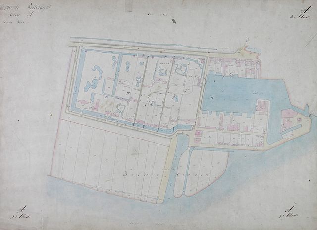
Nederlands: Kadastrale kaart van het Nieuwe Werk. Het afgebeelde gebied wordt begrensd door de Schiedamsche Dijk [Westzeedijk], de Zalmhaven, de Nieuwe Maas en de Dijk aan het Nieuwe Werk [Kievitslaan]
Datering:1827 (Geschat) |
| Date | |
| Source | http://collecties.stadsarchief.rotterdam.nl/publiek/detail.aspx?xmldescid=598795&tag=afbeeldingen;beeld;geluid;algemeen;video;film;bestellen&view=lijst&volgnummer=0&positie=10&beschrijvingssoort=157879244&doc_beschrijvingssoort=157879244&a_z=%5BARGS_PLACEHOLDER%5D |
| Author | Unknown author |
Licensing edit
|
This work is in the public domain in its country of origin and other countries and areas where the copyright term is the author's life plus 70 years or fewer. This work is in the public domain in the United States because it was published (or registered with the U.S. Copyright Office) before January 1, 1929. | |
| This file has been identified as being free of known restrictions under copyright law, including all related and neighboring rights. | |
File history
Click on a date/time to view the file as it appeared at that time.
| Date/Time | Thumbnail | Dimensions | User | Comment | |
|---|---|---|---|---|---|
| current | 10:20, 23 July 2016 | | 1,123 × 816 (436 KB) | Bic (talk | contribs) | User created page with UploadWizard |
You cannot overwrite this file.
File usage on Commons
The following page uses this file:
File usage on other wikis
The following other wikis use this file:
- Usage on fr.wikipedia.org