File:Kaffirland map.png

Size of this preview: 354 × 600 pixels. Other resolutions: 141 × 240 pixels | 283 × 480 pixels | 453 × 768 pixels | 1,120 × 1,898 pixels.
Original file (1,120 × 1,898 pixels, file size: 241 KB, MIME type: image/png)
Captions
Captions
Add a one-line explanation of what this file represents
Summary
edit
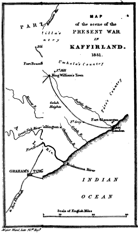
| Description |
English: A sketch map of the Xhosa region beside British South Africa, called Kaffraria/Kaffirland in the 1840s |
| Date | |
| Source |
Five years in Kaffirland : with sketches of the late war in that country to the conclusion of peace : written on the spot. (Third edition, London 1851) |
| Author | Harriet Ward (d.1873). Map by her husband (b.1798) |
Licensing
edit
|
This work is in the public domain in its country of origin and other countries and areas where the copyright term is the author's life plus 70 years or fewer. This work is in the public domain in the United States because it was published (or registered with the U.S. Copyright Office) before January 1, 1929. | |
| This file has been identified as being free of known restrictions under copyright law, including all related and neighboring rights. | |
File history
Click on a date/time to view the file as it appeared at that time.
| Date/Time | Thumbnail | Dimensions | User | Comment | |
|---|---|---|---|---|---|
| current | 15:15, 21 November 2016 | | 1,120 × 1,898 (241 KB) | Lelijg (talk | contribs) | User created page with UploadWizard |
You cannot overwrite this file.
File usage on Commons
There are no pages that use this file.
File usage on other wikis
The following other wikis use this file:
- Usage on en.wikipedia.org
- Usage on ig.wikipedia.org