File:Kagoshima Prefectural Kamoike Park.jpg
Size of this preview: 800 × 475 pixels. Other resolutions: 320 × 190 pixels | 640 × 380 pixels | 857 × 509 pixels.
Original file (857 × 509 pixels, file size: 206 KB, MIME type: image/jpeg)
Captions
Captions
Add a one-line explanation of what this file represents
Summary edit
| Description |
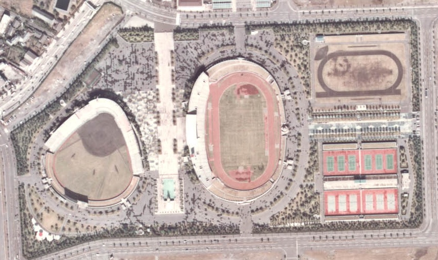
日本語: 鹿児島県立鴨池公園の1972年ごろの上空航空写真。 |
| Date | |
| Source | 国土画像情報(カラー空中写真) 国土交通省 |
| Author | 国土交通省 改変Sakoppi |
Licensing edit

|
The copyright holder of this file, the Ministry of Land, Infrastructure, Transport and Tourism of Japan, allows anyone to use it for any purpose, provided that the copyright holder is properly attributed. Redistribution, derivative work, commercial use, and all other use is permitted. |
Attribution:
Copyright © National Land Image Information (Color Aerial Photographs), Ministry of Land, Infrastructure, Transport and Tourism
|
 |
This image is copyrighted by the Ministry of Land, Infrastructure, Transport and Tourism of Japan. For terms of use, see the stipulation to use of National Land Information (in Japanese) and message from MLIT (in Japanese and English). When you display this image on an article, include the following phrase in the description: "Made based on National Land Image Information (Color Aerial Photographs), Ministry of Land, Infrastructure, Transport and Tourism".
|
File history
Click on a date/time to view the file as it appeared at that time.
| Date/Time | Thumbnail | Dimensions | User | Comment | |
|---|---|---|---|---|---|
| current | 06:34, 21 April 2012 | | 857 × 509 (206 KB) | Sakoppi (talk | contribs) | {{Information |Description ={{ja|1=鹿児島県立鴨池公園の1972年ごろの上空航空写真。}} |Source =[http://w3land.mlit.go.jp/WebGIS/ 国土画像情報(カラー空中写真)] 国土交通省 |Author =国土交通... |
You cannot overwrite this file.
File usage on Commons
There are no pages that use this file.
File usage on other wikis
The following other wikis use this file:
- Usage on ja.wikipedia.org
- Usage on www.wikidata.org