File:Kaiaraara Island (Mill Island).jpg

Size of this preview: 800 × 533 pixels. Other resolutions: 320 × 213 pixels | 640 × 427 pixels | 1,024 × 683 pixels | 1,280 × 853 pixels | 2,160 × 1,440 pixels.
Original file (2,160 × 1,440 pixels, file size: 795 KB, MIME type: image/jpeg)
Captions
Captions
Add a one-line explanation of what this file represents
Summary
edit.jpg&action=edit§ion=1)
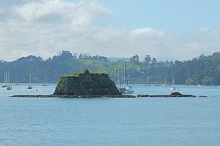
| Description | Kaiaraara Island (Mill Island) from north; this photo was taken from near the Russell wharf |
| Date | |
| Source | Own work |
| Author | Pseudopanax at English Wikipedia |
| Camera location | | View this and other nearby images on: OpenStreetMap |
|---|
.jpg¶ms=-35.262500_N_0174.119444_E_globe:Earth_type:camera__&language=en)
Licensing
edit.jpg&action=edit§ion=2)
| I, the copyright holder of this work, release this work into the public domain. This applies worldwide. In some countries this may not be legally possible; if so: I grant anyone the right to use this work for any purpose, without any conditions, unless such conditions are required by law. |
File history
Click on a date/time to view the file as it appeared at that time.
| Date/Time | Thumbnail | Dimensions | User | Comment | |
|---|---|---|---|---|---|
| current | 02:32, 2 July 2018 | | 2,160 × 1,440 (795 KB) | Pseudopanax (talk | contribs) | == {{int:filedesc}} == {{Information |Description=Kaiaraara Island (Mill Island) from north; this photo was taken from near the Russell wharf |Source={{Own}} |Date=2018-01-24 |Author={{user at project|Pseudopanax|wikipedia|en}} }} {{location|35|15|45|S|174|7|10|E}} == {{int:license-header}} == {{PD-self}} Category:Islands of the Bay of Islands Category:Uninhabited islands of New Zealand |
You cannot overwrite this file.
File usage on Commons
There are no pages that use this file.
.jpg&oldid=530231787)