File:Kaim of Mathers Castle and Rock Hall Fishing Station - geograph.org.uk - 1283471.jpg
No higher resolution available.
Kaim_of_Mathers_Castle_and_Rock_Hall_Fishing_Station_-_geograph.org.uk_-_1283471.jpg (640 × 480 pixels, file size: 91 KB, MIME type: image/jpeg)
Captions
Captions
Add a one-line explanation of what this file represents
Summary
edit
| Description |
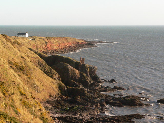
English: Kaim of Mathers Castle and Rock Hall Fishing Station Looking slightly north of east over the precarious ruins of the Kaim of Mathers castle atop a narrow rocky promontory, riven with passages and caves below, towards the restored former salmon fishing station at Rock Hall and then onwards to Milton Ness, the principal geographical feature of this grid square. The foreground is designated as an SSSI for its botanical interest and the background is a separate SSSI, designated for its geomorphological interest. |
| Date | |
| Source | From geograph.org.uk |
| Author | Andrew Hamilton |
| Attribution (required by the license) | Andrew Hamilton / Kaim of Mathers Castle and Rock Hall Fishing Station / |
| Camera location | | View this and other nearby images on: OpenStreetMap |
|---|
_heading:90.00&language=en)
| Object location | | View this and other nearby images on: OpenStreetMap |
|---|
_heading:90.00&language=en)
Licensing
edit

|
This image was taken from the Geograph project collection. See this photograph's page on the Geograph website for the photographer's contact details. The copyright on this image is owned by Andrew Hamilton and is licensed for reuse under the Creative Commons Attribution-ShareAlike 2.0 license.
|
This file is licensed under the Creative Commons Attribution-Share Alike 2.0 Generic license.
Attribution: Andrew Hamilton
- You are free:
- to share – to copy, distribute and transmit the work
- to remix – to adapt the work
- Under the following conditions:
- attribution – You must give appropriate credit, provide a link to the license, and indicate if changes were made. You may do so in any reasonable manner, but not in any way that suggests the licensor endorses you or your use.
- share alike – If you remix, transform, or build upon the material, you must distribute your contributions under the same or compatible license as the original.
File history
Click on a date/time to view the file as it appeared at that time.
| Date/Time | Thumbnail | Dimensions | User | Comment | |
|---|---|---|---|---|---|
| current | 06:23, 27 February 2011 | | 640 × 480 (91 KB) | GeographBot (talk | contribs) | == {{int:filedesc}} == {{Information |description={{en|1=Kaim of Mathers Castle and Rock Hall Fishing Station Looking slightly north of east over the precarious ruins of the Kaim of Mathers castle atop a narrow rocky promontory, riven with passages and ca |
You cannot overwrite this file.
File usage on Commons
There are no pages that use this file.