File:Kaitei Kansen map ja.png

Size of this preview: 800 × 549 pixels. Other resolutions: 320 × 220 pixels | 640 × 439 pixels | 855 × 587 pixels.
Original file (855 × 587 pixels, file size: 49 KB, MIME type: image/png)
Captions
Captions
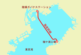
Map of "Kaitei-kansen" pipeline, Tokyo Gas Corporation
Summary
edit
| Description |
日本語: 東京ガスが1976年から1977年にかけて敷設した、東京湾をくぐり袖ケ浦と新木場を結ぶ天然ガスパイプライン「海底幹線」の概要地図
English: Abstract map of "Kaitei-kansen" natural gas pipeline which connects Sodegaura and Shinkiba under the Bay of Tokyo, constructed by Tokyo Gas Corporation from 1976 to 1977. |
| Date | |
| Source | Own work |
| Author | Tam0031 |
Licensing
edit
I, the copyright holder of this work, hereby publish it under the following license:
This file is licensed under the Creative Commons Attribution-Share Alike 4.0 International license.
- You are free:
- to share – to copy, distribute and transmit the work
- to remix – to adapt the work
- Under the following conditions:
- attribution – You must give appropriate credit, provide a link to the license, and indicate if changes were made. You may do so in any reasonable manner, but not in any way that suggests the licensor endorses you or your use.
- share alike – If you remix, transform, or build upon the material, you must distribute your contributions under the same or compatible license as the original.
File history
Click on a date/time to view the file as it appeared at that time.
| Date/Time | Thumbnail | Dimensions | User | Comment | |
|---|---|---|---|---|---|
| current | 15:46, 23 February 2020 | | 855 × 587 (49 KB) | Tam0031 (talk | contribs) | User created page with UploadWizard |
You cannot overwrite this file.
File usage on Commons
The following page uses this file:
File usage on other wikis
The following other wikis use this file:
- Usage on ja.wikipedia.org