File:Kalgin Island from space.jpg

Size of this preview: 800 × 547 pixels. Other resolutions: 320 × 219 pixels | 640 × 438 pixels | 1,024 × 700 pixels | 1,275 × 872 pixels.
Original file (1,275 × 872 pixels, file size: 756 KB, MIME type: image/jpeg)
Captions
Captions
Add a one-line explanation of what this file represents
Summary
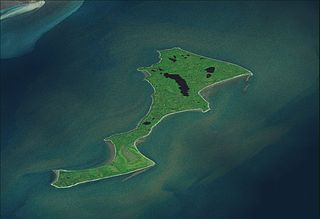
edit| Description |
Română: Kalgin Island from space. |
| Source | Topographic data SRTM from NASA and World Imagery - NASA World Wind & 3Dem & Inkscape |
| Author | Asybaris01 |
Licensing
edit| This image is in the public domain because it is a screenshot from NASA’s globe software World Wind using a public domain layer, such as Blue Marble, MODIS, Landsat, SRTM, USGS or GLOBE.
|
 |

File history
Click on a date/time to view the file as it appeared at that time.
| Date/Time | Thumbnail | Dimensions | User | Comment | |
|---|---|---|---|---|---|
| current | 18:53, 7 October 2011 | | 1,275 × 872 (756 KB) | Asybaris01 (talk | contribs) | {{Information |Description ={{ro|1=Kalgin Island from space.}} |Source =Topographic data SRTM from NASA and World Imagery - NASA World Wind & 3Dem & Inkscape |Author =Asybaris01 |Date = |Permission = |o |
You cannot overwrite this file.
File usage on Commons
There are no pages that use this file.
File usage on other wikis
The following other wikis use this file:
- Usage on en.wikipedia.org
- Usage on it.wikipedia.org
- Usage on ja.wikipedia.org
- Usage on zh.wikipedia.org