File:Kamikoshiki Island Namako Pond Aerial photo.png
No higher resolution available.
Kamikoshiki_Island_Namako_Pond_Aerial_photo.png (502 × 263 pixels, file size: 301 KB, MIME type: image/png)
Captions
Captions
Add a one-line explanation of what this file represents
Summary edit
| Description |
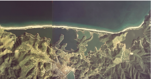
日本語: 鹿児島県の甑島列島・上甑島、長目の浜となまこ池(左から中央まで)、貝池(中央やや右)、鍬崎池(右) |
| Date | |
| Source | Japanese Ministry of Land, Infrastructure, Transport and Tourism |
| Author | Retouched by At by At |
- 整理番号 CKU-77-9
- 撮影年度 昭和52年度
- 地区名 甑島
- 撮影コース・写真番号 C6-1, C5-2
Licensing edit

|
The copyright holder of this file, the Ministry of Land, Infrastructure, Transport and Tourism of Japan, allows anyone to use it for any purpose, provided that the copyright holder is properly attributed. Redistribution, derivative work, commercial use, and all other use is permitted. |
Attribution:
Copyright © National Land Image Information (Color Aerial Photographs), Ministry of Land, Infrastructure, Transport and Tourism
|
 |
This image is copyrighted by the Ministry of Land, Infrastructure, Transport and Tourism of Japan. For terms of use, see the stipulation to use of National Land Information (in Japanese) and message from MLIT (in Japanese and English). When you display this image on an article, include the following phrase in the description: "Made based on National Land Image Information (Color Aerial Photographs), Ministry of Land, Infrastructure, Transport and Tourism".
|
File history
Click on a date/time to view the file as it appeared at that time.
| Date/Time | Thumbnail | Dimensions | User | Comment | |
|---|---|---|---|---|---|
| current | 01:40, 24 September 2013 | | 502 × 263 (301 KB) | At by At (talk | contribs) | User created page with UploadWizard |
You cannot overwrite this file.
File usage on Commons
The following page uses this file: