File:KanagawaMapCurrent ja.png

Size of this preview: 800 × 500 pixels. Other resolutions: 320 × 200 pixels | 640 × 400 pixels | 1,024 × 640 pixels | 1,281 × 801 pixels.
Original file (1,281 × 801 pixels, file size: 147 KB, MIME type: image/png)
Captions
Captions
Add a one-line explanation of what this file represents
Summary
edit
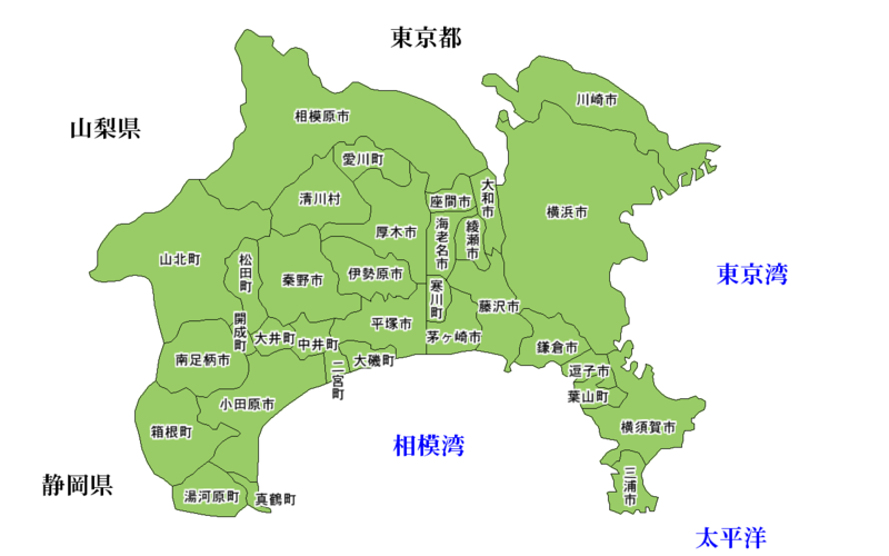
Map of Kanagawa Prefecture, Japan.
神奈川県の地図。
Thanks to Aoki Shigenobu and [1]. Colors from Image:TokyoMapCurrent.png by User:Fg2. Image:KanagawaMapCurrent.pngを元に作成。
Licensing
edit

|
Shigenobu AOKI, the copyright holder of this work, allows anyone to use it for any purpose including unrestricted redistribution, commercial use, and modification. |
File history
Click on a date/time to view the file as it appeared at that time.
| Date/Time | Thumbnail | Dimensions | User | Comment | |
|---|---|---|---|---|---|
| current | 14:31, 30 March 2009 | | 1,281 × 801 (147 KB) | Pqks758 (talk | contribs) | 市町村名を加筆 |
| 20:50, 24 March 2007 |  | 1,281 × 801 (48 KB) | Pqks758 (talk | contribs) | ||
| 19:21, 31 January 2007 |  | 1,281 × 801 (48 KB) | Pqks758 (talk | contribs) | ||
| 19:08, 31 January 2007 |  | 1,281 × 801 (49 KB) | Pqks758 (talk | contribs) | == Summary == Map of Kanagawa Prefecture, Japan. 神奈川県の地図 Thanks to Aoki Shigenobu and [http://aoki2.si.gunma-u.ac.jp/map/map.html]. Colors from Image:TokyoMapCurrent.png by User:Fg2. [[:Image:KanagawaMapCurre |
You cannot overwrite this file.
File usage on Commons
There are no pages that use this file.