File:Kanawha River Valley and Fayetteville.png

Size of this preview: 546 × 599 pixels. Other resolutions: 219 × 240 pixels | 437 × 480 pixels | 700 × 768 pixels.
Original file (700 × 768 pixels, file size: 1.05 MB, MIME type: image/png)
Captions
Captions
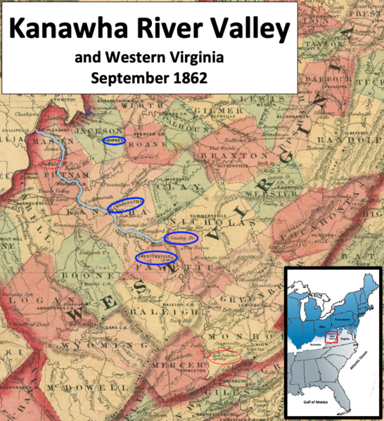
The Kanawha River flowed northwest to the Ohio River
Summary
edit
| Description |
English: This map shows western Virginia during September 1862 during the American Civil War. A Union force at the head of the Kanawha Valley, commanded by Colonel Joseph Andrew Jackson Lightburn, was threatened by a Confederate force commanded by Major General William W. Loring. Loring had cavalry downriver at Buffalo, while Loring was in Giles and Monroe counties preparing to attack Fayetteville. |
| Date | |
| Source | This is a crop from Johnson's Delaware, Maryland & Virginia map published in 1864. It can be found in the U.S. Library of Congress here. Labels and circles have been added by TwoScarsUp based on the book named "The Battle of Charleston and the 1862 Kanawha Valley Campaign" by Terry Lowry. |
| Author | The map is by Alvin Jewett Johnson (1827-1884), and was published in 1864. TwoScarsUp made modifications. |
Licensing
edit
|
This work is in the public domain in its country of origin and other countries and areas where the copyright term is the author's life plus 70 years or fewer. This work is in the public domain in the United States because it was published (or registered with the U.S. Copyright Office) before January 1, 1929. | |
| This file has been identified as being free of known restrictions under copyright law, including all related and neighboring rights. | |
File history
Click on a date/time to view the file as it appeared at that time.
| Date/Time | Thumbnail | Dimensions | User | Comment | |
|---|---|---|---|---|---|
| current | 17:32, 10 December 2022 | | 700 × 768 (1.05 MB) | TwoScarsUp (talk | contribs) | Uploaded a work by The map is by Alvin Jewett Johnson (1827-1884), and was published in 1864. TwoScarsUp made modifications. from This is a crop from Johnson's Delaware, Maryland & Virginia map published in 1864. It can be found in the U.S. Library of Congress [https://www.loc.gov/item/lva0000026/ here]. Labels and circles have been added by TwoScarsUp based on the book named "The Battle of Charleston and the 1862 Kanawha Valley Campaign" by Terry Lowry. with UploadWizard |
You cannot overwrite this file.
File usage on Commons
There are no pages that use this file.
File usage on other wikis
The following other wikis use this file:
- Usage on en.wikipedia.org