File:Kangaroo Island, Australia.jpg

Original file (3,543 × 2,540 pixels, file size: 1.12 MB, MIME type: image/jpeg)
Captions
Captions
Summary
edit
| Description |
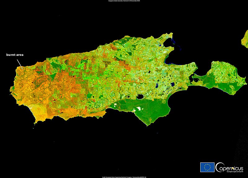
English: Climate change is causing multiple wildfire crises around the world and putting biodiversity at risk. According to a new study led by researchers of the University of Melbourne, a significant increase in wildfire activity is putting more than 4,400 species across the globe at risk. These include birds, mammals and many plants already at risk of extinction. Researchers also identified three major man-made drivers (global climate change, land-use and biotic invasions) behind the increase in fire activity which are having a devastating impact on biodiversity. The consequences of the bushfires from the last austral summer are visible in this image acquired on 25 November 2020 by one of the Copernicus Sentinel-2 satellites. It shows Kangaroo Island, one of the most biodiverse islands of Australia, where 210,000 hectares of land, nearly half of the area of the island, burned down. Additionally, the islands kangaroo population was almost decimated by the fires which raged from December 2019 to January 2020. With a revisit time of five days on average at the equator, the Copernicus Sentinel-2 satellites deliver free and open data which can be used to monitor wildfires and their impact on land and vegetation. |
| Date | Taken on 25 November 2020 |
| Source | Kangaroo Island, Australia |
| Author | European Union , Copernicus Sentinel-2 imagery |
Licensing
edit

|
This image contains data from a satellite in the Copernicus Programme, such as Sentinel-1, Sentinel-2 or Sentinel-3. Attribution is required when using this image.
Attribution: Contains modified Copernicus Sentinel data 2020
The use of Copernicus Sentinel Data is regulated under EU law (Commission Delegated Regulation (EU) No 1159/2013 and Regulation (EU) No 377/2014). Relevant excerpts:
Free access shall be given to GMES dedicated data [...] made available through GMES dissemination platforms [...].
Access to GMES dedicated data [...] shall be given for the purpose of the following use in so far as it is lawful:
GMES dedicated data [...] may be used worldwide without limitations in time.
GMES dedicated data and GMES service information are provided to users without any express or implied warranty, including as regards quality and suitability for any purpose. |
File history
Click on a date/time to view the file as it appeared at that time.
| Date/Time | Thumbnail | Dimensions | User | Comment | |
|---|---|---|---|---|---|
| current | 11:34, 24 August 2023 | | 3,543 × 2,540 (1.12 MB) | OptimusPrimeBot (talk | contribs) | #Spacemedia - Upload of https://www.copernicus.eu/system/files/2020-11/image_day/KangarooIsland_credit_row2.jpg via Commons:Spacemedia |
You cannot overwrite this file.
File usage on Commons
The following 2 pages use this file:
File usage on other wikis
The following other wikis use this file:
- Usage on ca.wikipedia.org
- Usage on www.wikidata.org