File:Karachi Transport Network.png

Size of this preview: 797 × 600 pixels. Other resolutions: 319 × 240 pixels | 638 × 480 pixels | 1,021 × 768 pixels | 1,280 × 963 pixels | 2,560 × 1,926 pixels | 2,828 × 2,128 pixels.
Original file (2,828 × 2,128 pixels, file size: 1.44 MB, MIME type: image/png)
Captions
Captions
Map of Kay
Summary edit
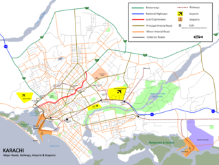
| Description | Map showing major roads, railway lines, ports and airports of the city of Karachi, Pakistan. |
| Source | Own work |
| Author | Nomi887 |
Licensing edit
I, the copyright holder of this work, hereby publish it under the following licenses:
This file is licensed under the Creative Commons Attribution-Share Alike 3.0 Unported license.
- You are free:
- to share – to copy, distribute and transmit the work
- to remix – to adapt the work
- Under the following conditions:
- attribution – You must give appropriate credit, provide a link to the license, and indicate if changes were made. You may do so in any reasonable manner, but not in any way that suggests the licensor endorses you or your use.
- share alike – If you remix, transform, or build upon the material, you must distribute your contributions under the same or compatible license as the original.

|
Permission is granted to copy, distribute and/or modify this document under the terms of the GNU Free Documentation License, Version 1.2 or any later version published by the Free Software Foundation; with no Invariant Sections, no Front-Cover Texts, and no Back-Cover Texts. A copy of the license is included in the section entitled GNU Free Documentation License. |
You may select the license of your choice.
File history
Click on a date/time to view the file as it appeared at that time.
| Date/Time | Thumbnail | Dimensions | User | Comment | |
|---|---|---|---|---|---|
| current | 14:06, 15 May 2012 | | 2,828 × 2,128 (1.44 MB) | Nomi887 (talk | contribs) | Refined and Corrected. |
| 09:48, 21 March 2012 |  | 3,265 × 2,569 (896 KB) | Nomi887 (talk | contribs) | General fixes. | |
| 07:18, 1 October 2010 |  | 3,265 × 2,569 (1.11 MB) | Nomi887 (talk | contribs) | Minor Changes. | |
| 06:32, 1 October 2010 |  | 3,265 × 2,569 (1.02 MB) | Nomi887 (talk | contribs) | size reduced. | |
| 06:15, 1 October 2010 |  | 4,663 × 3,670 (1.12 MB) | Nomi887 (talk | contribs) | {{Information |Description= Transportation Network of the City of Karachi, Pakistan. |Source={{own}} |Date= |Author= Nomi887 |Permission= |other_versions= }} |
You cannot overwrite this file.
File usage on Commons
There are no pages that use this file.
File usage on other wikis
The following other wikis use this file:
- Usage on ar.wikipedia.org
- Usage on az.wikipedia.org
- Usage on bn.wikipedia.org
- Usage on ceb.wikipedia.org
- Usage on ckb.wikipedia.org
- Usage on en.wikipedia.org
- Karachi
- List of universities in Karachi
- University of Karachi
- NED University of Engineering & Technology
- Hill Park, Karachi
- Karachi Safari Park
- Karachi Zoo
- National Stadium, Karachi
- Manghopir
- Pakistan Air Force Museum
- Pir Mangho
- PAF Base Masroor
- Iqra University
- UIT University
- Federal Urdu University
- Boat Basin
- PAF Base Faisal
- Shri Swaminarayan Mandir, Karachi
- User:Nomi887
- Module:Location map/data/Pakistan Karachi/doc
- Indo-Pakistani Naval War of 1971
- Greenwich University, Karachi
- 2012 Pakistan factory fires
- Polo Ground, Karachi
- National Bank of Pakistan Sports Complex
- Karachi Harbour
- Naya Nazimabad
- 2014 Jinnah International Airport attack
- Manora Fort, Karachi
- EFU House
- Grand Jamia Mosque
- User:Zohaibahmed123
- User:Ngrewal1/sandbox
- Module:Location map/data/Pakistan Karachi
- Module:Location map/data/Karachi
- Clifton Urban Forest
- Karachi Chinese consulate attack
- New Memon Masjid
- Baitul Mukarram Mosque
- 2022–23 Pakistan Cup
- Rangers Anti-Terrorism Wing
- Chinna Creek
- Usage on eo.wikipedia.org
- Usage on fa.wikipedia.org
View more global usage of this file.