File:Karta över Wien på 1920-talet (ur Nordisk familjebok).jpg

Original file (2,548 × 3,480 pixels, file size: 2.32 MB, MIME type: image/jpeg)
Captions
Captions
Summary edit
.jpg&action=edit§ion=1)
| Description |
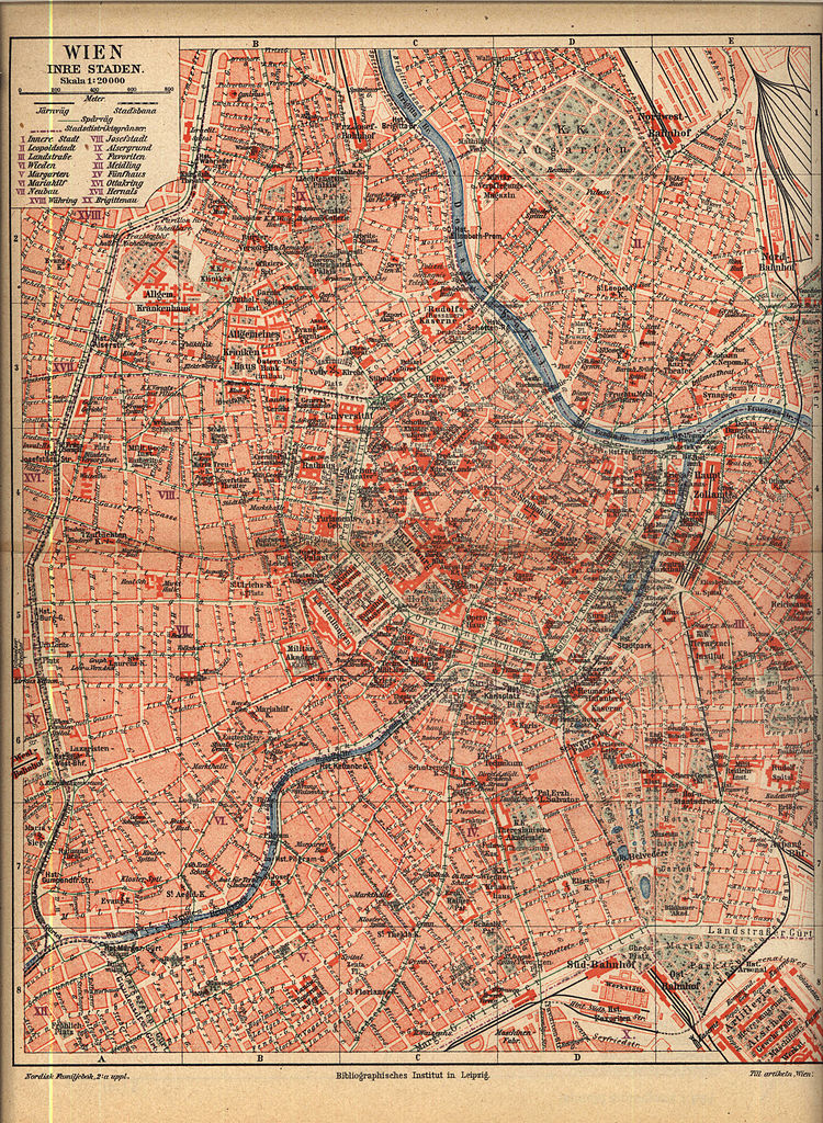
Svenska: Karta över Wien på 1920-talet
English: Map of Vienna during World War I (1914-18)
Čeština: Mapa Vídně z 20. let 20. století
Deutsch: Plan von Wien innerhalb des Gürtels mit Stand zwischen 1914 und 1918 |
| Date | betw. 1914-1918 |
| Source | Nordisk familjebok, 2:a uppl. |
| Author | Biblographisches Institut Leipzig |
| Open this image as an overlay in Google Earth (Google Maps, Bing) | (Help|Source) |
.jpg/overlay.kml)
Date-Range edit
.jpg&action=edit§ion=2)
Concerning the date of this map, we have to look at hints dating from the period in question.
Obviously it was still monarchy (until 1918) because the "K.K." ("kaiserlich-königlich") prefix is used
frequently. A valuable piece of information is the tag "Österr.-Ung. Bank (im Bau)" (now: Nationalbank) which means
the period 1913-18. Finally, what used to be "Staats-Bahnhof" is called "Ost-Bahnhof" here, and this renaming
was in 1914.
Hence, the map must date from the time between 1914 and 18, coinciding with World War I. Further specification might
be difficult since there was little building activity during that time. Mueffi 22:54, 12 January 2006 (UTC)
This image was first published in the 1st (1876–1899), 2nd (1904–1926) or 3rd (1923–1937) edition of Nordisk familjebok. The copyrights for that book have expired and this image is in the public domain, because images had no named authors and the book was published more than 70 years ago.
|
This image (or other media file) is in the public domain because its copyright has expired and its author is anonymous.
This applies to the European Union and those countries with a copyright term of 70 years after the work was made available to the public and the author never disclosed their identity. Important: Always mention where the image comes from, as far as possible, and make sure the author never claimed authorship. |
 | |
 |
Note: In Germany and possibly other countries, certain anonymous works published before July 1, 1995 are copyrighted until 70 years after the death of the author. See Übergangsrecht. Please use this template only if the author never claimed authorship or their authorship never became public in any other way. If the work is anonymous or pseudonymous (e.g., published only under a corporate or organization's name), use this template for images published more than 70 years ago.
For a work made available to the public in the United Kingdom, please use Template:PD-UK-unknown instead.
|
File history
Click on a date/time to view the file as it appeared at that time.
| Date/Time | Thumbnail | Dimensions | User | Comment | |
|---|---|---|---|---|---|
| current | 22:21, 26 April 2005 | | 2,548 × 3,480 (2.32 MB) | Den fjättrade ankan~commonswiki (talk | contribs) | *{{Svenska}} Karta över Wien på 1920-talet *{{English}} Map of Vienna at the 1920s *Source: Nordisk familjebok {{PD-Ugglan}} Category:20th century maps Category:Vienna |
You cannot overwrite this file.
File usage on Commons
The following page uses this file:
File usage on other wikis
The following other wikis use this file:
- Usage on de.wikipedia.org
- Usage on sv.wikipedia.org
.jpg&oldid=797137314)