File:Karta Poroishte coords.png
No higher resolution available.
Karta_Poroishte_coords.png (202 × 134 pixels, file size: 3 KB, MIME type: image/png)
Captions
Captions
Add a one-line explanation of what this file represents
Summary
edit
| Description |
Български: За изработена е за едно обсъждане
Автор: Петко Йотов 2006 |
| Date | 19 February 2006 (original upload date) |
| Source | Transferred from bg.wikipedia to Commons. |
| Author | The original uploader was Петко at Bulgarian Wikipedia. |
| Camera location | | View this and other nearby images on: OpenStreetMap |
|---|
Licensing
edit
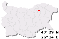
Български: Карта на България с червена точка, автор Петко Йотов (User:5ko) 2004, 2005 или 2006. Географски координати, ползвани при изработването: 43° 29' северна ширина, 26° 34' източна дължина и предполагаема приблизителна надморска височина от 301 метра.
English: Bulgaria map with a red dot, © Petko Yotov (User:5ko) 2004, 2005 or 2006. Coordinates: North: 43° 29', East 26° 34', and approx. altitude 301 metres.
Български: Подложката е изработена с MS Paint и IrfanView и е "производна работа" на de:Bild:Sofia in BG.png, автор Рони Хайденрайх, GFDL.
English: The template map is created with MS Paint and IrfanView and is a "derivative work" from de:Bild:Sofia in BG.png, author Ronny Heidenreich, GFDL.

|
Permission is granted to copy, distribute and/or modify this document under the terms of the GNU Free Documentation License, Version 1.2 or any later version published by the Free Software Foundation; with no Invariant Sections, no Front-Cover Texts, and no Back-Cover Texts. A copy of the license is included in the section entitled GNU Free Documentation License. |
| This file is licensed under the Creative Commons Attribution-Share Alike 3.0 Unported license. | ||
| ||
| This licensing tag was added to this file as part of the GFDL licensing update. |
Външни препратки (тестване):
Ако картата е неточна, бихте могли да я промените/коригирате чрез скрипта Карти на България за Уикипедия. Вижте също bg:У:КБЧТ и bg:У:СНМБ. |
За да въведете координатите в таблицата на статията за населените места, използвайте:
|
Original upload log
edit
The original description page was here. All following user names refer to bg.wikipedia.
- 2006-02-19 14:58 Петко 202×134× (2764 bytes) Автор: Петко Йотов 2006 {{GFDL}}
File history
Click on a date/time to view the file as it appeared at that time.
| Date/Time | Thumbnail | Dimensions | User | Comment | |
|---|---|---|---|---|---|
| current | 10:26, 30 September 2012 | | 202 × 134 (3 KB) | Nk (talk | contribs) | {{Information |Description={{bg|За изработена е за едно обсъждане Автор: Петко Йотов 2006}} |Source=Transferred from [http://bg.wikipedia.org bg.wikipedia] |Date={{Original upload date|2006-02-19}} |Author=Or... |
You cannot overwrite this file.
File usage on Commons
There are no pages that use this file.
File usage on other wikis
The following other wikis use this file:
- Usage on bg.wikipedia.org