File:Karte - A new map of Electorate Bavaria - 1794.jpg

Size of this preview: 629 × 599 pixels. Other resolutions: 252 × 240 pixels | 504 × 480 pixels | 806 × 768 pixels | 1,075 × 1,024 pixels | 2,099 × 2,000 pixels.
Original file (2,099 × 2,000 pixels, file size: 5.27 MB, MIME type: image/jpeg)
Captions
Captions
Add a one-line explanation of what this file represents
Summary
edit
| Description |
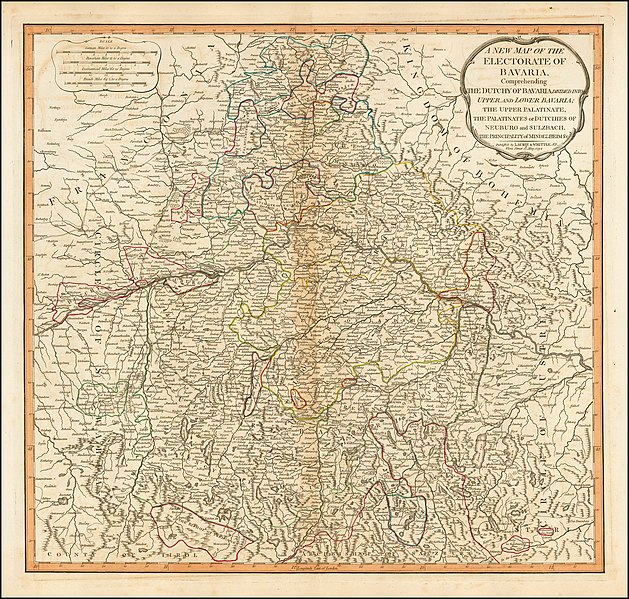
Deutsch: Karte des Kurfürstentums Bayern: "A New Map of the Electorate of Bavaria, Comprehending The Dutchy of Bavaria Divided Into Upper and Lower Bavaria; The Upper Palatinate, the Palatinates or Dutchies of Neuburg and Sulzbach." London 1794, Laurie & Whittle. |
| Source | https://img.raremaps.com/xlarge/49135.jpg |
| Author | Unknown author |
Licensing
edit
|
This work is in the public domain in its country of origin and other countries and areas where the copyright term is the author's life plus 70 years or fewer. | |
| This file has been identified as being free of known restrictions under copyright law, including all related and neighboring rights. | |
File history
Click on a date/time to view the file as it appeared at that time.
| Date/Time | Thumbnail | Dimensions | User | Comment | |
|---|---|---|---|---|---|
| current | 08:24, 28 July 2019 | | 2,099 × 2,000 (5.27 MB) | DALIBRI (talk | contribs) | {{Information |description ={{de|1=Karte des Kurfürstentums Bayern: "A New Map of the Electorate of Bavaria, Comprehending The Dutchy of Bavaria Divided Into Upper and Lower Bavaria; The Upper Palatinate, the Palatinates or Dutchies of Neuburg and Sulzbach." London 1794, Laurie & Whittle. }} |date = |source =https://img.raremaps.com/xlarge/49135.jpg |author ={{unknown|author}} }} Category:Maps of the Electorate of Bavaria Category:Bavaria in the 18th century |
You cannot overwrite this file.
File usage on Commons
There are no pages that use this file.
File usage on other wikis
The following other wikis use this file:
- Usage on de.wikipedia.org