File:Karte A Noe MI 2017.svg

Size of this PNG preview of this SVG file: 649 × 600 pixels. Other resolutions: 260 × 240 pixels | 520 × 480 pixels | 831 × 768 pixels | 1,108 × 1,024 pixels | 2,217 × 2,048 pixels | 1,050 × 970 pixels.
Original file (SVG file, nominally 1,050 × 970 pixels, file size: 56 KB)
Captions
Captions
Add a one-line explanation of what this file represents
Summary edit
| Description |
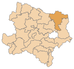
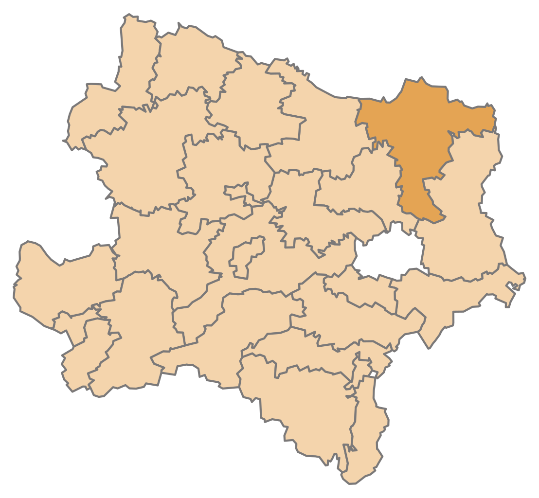
English: Map of the Austrian State Lower Austria, highlighting District Mistelbach (District boundaries valid from 2017)
Deutsch: Karte des österreichischen Bundeslandes Niederösterreich, Bezirk Mistelbach hervorgehoben (Bezirksgrenzen gültig ab Jänner 2017) |
| Date | |
| Source | Own work |
| Author | AleXXw |
Licensing edit
I, the copyright holder of this work, hereby publish it under the following license:
This file is licensed under the Creative Commons Attribution-Share Alike 4.0 International license.
- You are free:
- to share – to copy, distribute and transmit the work
- to remix – to adapt the work
- Under the following conditions:
- attribution – You must give appropriate credit, provide a link to the license, and indicate if changes were made. You may do so in any reasonable manner, but not in any way that suggests the licensor endorses you or your use.
- share alike – If you remix, transform, or build upon the material, you must distribute your contributions under the same or compatible license as the original.
File history
Click on a date/time to view the file as it appeared at that time.
| Date/Time | Thumbnail | Dimensions | User | Comment | |
|---|---|---|---|---|---|
| current | 13:05, 12 November 2016 | | 1,050 × 970 (56 KB) | AleXXw (talk | contribs) | Colorfix |
| 12:07, 12 November 2016 |  | 1,050 × 970 (56 KB) | AleXXw (talk | contribs) | User created page with UploadWizard |
You cannot overwrite this file.
File usage on Commons
The following 3 pages use this file:
File usage on other wikis
The following other wikis use this file:
- Usage on cs.wikipedia.org
- Usage on de.wikipedia.org
- Bezirk Mistelbach
- Wolkersdorf im Weinviertel
- Laa an der Thaya
- Poysdorf
- Bockfließ
- Mistelbach (Niederösterreich)
- Vorlage:Navigationsleiste Städte und Gemeinden im Bezirk Mistelbach
- Wildendürnbach
- Altlichtenwarth
- Asparn an der Zaya
- Bernhardsthal
- Drasenhofen
- Falkenstein (Niederösterreich)
- Fallbach
- Gaubitsch
- Gaweinstal
- Gnadendorf
- Großebersdorf
- Großengersdorf
- Großharras
- Großkrut
- Hausbrunn
- Herrnbaumgarten
- Hochleithen
- Kreuttal
- Kreuzstetten
- Ladendorf
- Neudorf im Weinviertel
- Niederleis
- Pillichsdorf
- Rabensburg
- Schrattenberg
- Staatz
- Stronsdorf
- Ulrichskirchen-Schleinbach
- Unterstinkenbrunn
- Wilfersdorf (Niederösterreich)
- Ottenthal
- Liste der Wappen im Bezirk Mistelbach
- Liste der Verwaltungsbezirke und Statutarstädte von Niederösterreich
- Denkmalgeschützte Objekte im Bezirk Mistelbach
- Wikipedia:WikiProjekt Österreich/checks/Navis/Niederösterreich 1
- Usage on eo.wikipedia.org
View more global usage of this file.