File:Karte Bhf Filisur.svg

Size of this PNG preview of this SVG file: 800 × 538 pixels. Other resolutions: 320 × 215 pixels | 640 × 430 pixels | 1,024 × 688 pixels | 1,280 × 861 pixels | 2,560 × 1,721 pixels | 827 × 556 pixels.
Original file (SVG file, nominally 827 × 556 pixels, file size: 630 KB)
Captions
Captions
Add a one-line explanation of what this file represents
Summary
edit
| Description |
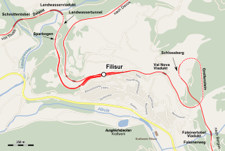
English: Location map of station Filisur, Landwasser Viaduct and Greifenstein Tunnel Deutsch: Lagekarte vom Bhf Filisur, Landwasserviadukt und Greifensteintunnel |
| Date | |
| Source | Map was created using Open Street Map Data |
| Author | Pechristener: rendering with Maperitive, text and integration |
| Permission (Reusing this file) |
Map data (c) OpenStreetMap (and) contributors, CC-BY-SA |
Licensing
edit
This file is licensed under the Creative Commons Attribution-Share Alike 2.0 Generic license.
- You are free:
- to share – to copy, distribute and transmit the work
- to remix – to adapt the work
- Under the following conditions:
- attribution – You must give appropriate credit, provide a link to the license, and indicate if changes were made. You may do so in any reasonable manner, but not in any way that suggests the licensor endorses you or your use.
- share alike – If you remix, transform, or build upon the material, you must distribute your contributions under the same or compatible license as the original.
| This work is licensed under the Open Database License (summary). |
File history
Click on a date/time to view the file as it appeared at that time.
| Date/Time | Thumbnail | Dimensions | User | Comment | |
|---|---|---|---|---|---|
| current | 09:01, 4 April 2022 | | 827 × 556 (630 KB) | Pechristener (talk | contribs) | Der Landwassertunnel war fälschlicherweise mit "Sparbogen" beschriftet. Dieser befindet sich aber südlich vom Tunnel |
| 19:17, 3 June 2017 |  | 827 × 556 (619 KB) | Pechristener (talk | contribs) | {{Information |Description={{en|1=Location map of station Filisur, Landwasser Viaduct and Greifensteint Tunnel }}{{de|1=Lagekarte vom Bhf Filisur, Landwasserviadukt und Greifensteintunnel}} |Source = Map was created using [http://www.openstreet... |
You cannot overwrite this file.
File usage on Commons
The following 8 pages use this file:
- Bergün Filisur
- Landwasserviadukt
- User:Chumwa/OgreBot/Potential transport maps/2017 June 1-10
- User:Chumwa/OgreBot/Public transport information/2017 June 1-10
- User:Chumwa/OgreBot/Public transport information/2022 April 1-10
- User:Chumwa/OgreBot/Transport Maps/2017 June 1-10
- User:Chumwa/OgreBot/Transport Maps/2022 April 1-10
- User:Chumwa/OgreBot/Travel and communication maps/2017 June 1-10
File usage on other wikis
The following other wikis use this file:
- Usage on de.wikipedia.org