File:Karte Liliental.png

Size of this preview: 448 × 599 pixels. Other resolutions: 179 × 240 pixels | 359 × 480 pixels | 574 × 768 pixels | 1,142 × 1,528 pixels.
Original file (1,142 × 1,528 pixels, file size: 405 KB, MIME type: image/png)
Captions
Captions
Add a one-line explanation of what this file represents
Summary
edit
| Description |
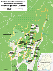
Deutsch: Karte des Versuchsgeländes Liliental der Forstlichen Versuchs- und Forschungsanstalt Baden-Württemberg |
|||
| Date | see file history | |||
| Source |
Own work, using
|
|||
| Author | Maximilian Dörrbecker (Chumwa) | |||
| Permission (Reusing this file) |
This file is licensed under the Creative Commons Attribution-Share Alike 2.0 Generic license.
Sie dürfen das Bild zu den folgenden Bedingungen nutzen:
|
File history
Click on a date/time to view the file as it appeared at that time.
| Date/Time | Thumbnail | Dimensions | User | Comment | |
|---|---|---|---|---|---|
| current | 17:45, 1 December 2019 | | 1,142 × 1,528 (405 KB) | Chumwa (talk | contribs) | Eisbeeren → Elsbeeren |
| 18:50, 1 April 2014 |  | 1,142 × 1,528 (391 KB) | Chumwa (talk | contribs) | == {{int:filedesc}} == {{Information |Description = {{de|1=Karte des Versuchsgeländes Liliental der Forstlichen Versuchs- und Forschungsanstalt Baden-Württemberg}} |Source={{own}}, using * OpenStreetMap data * kaiserstuhl.net: [http://kaisers... |
You cannot overwrite this file.
File usage on Commons
The following 4 pages use this file:
File usage on other wikis
The following other wikis use this file:
- Usage on de.wikipedia.org
- Usage on www.wikidata.org