File:Karte Mährerreich Mojmír I.png

Original file (1,126 × 994 pixels, file size: 1.14 MB, MIME type: image/png)
Captions
Captions
Summary edit
| Description |
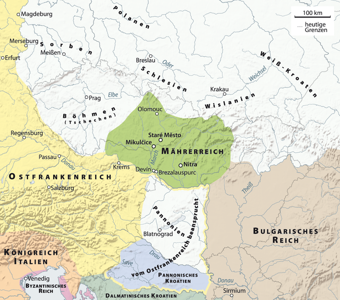
Deutsch: Karte des Mährerreichs unter Mojmír I. und die Nachbarländer. Die Darstellung der Gewässer entspricht dem heutigen Stand. |
| Date | |
| Source |
Own work using:
|
| Author | NordNordWest |

|
This map has been made or improved in the German Kartenwerkstatt (Map Lab). You can propose maps to improve as well.
|
Licensing edit
Usage of this file with:

explanatory notes: Legally binding is only the full legalcode. For a free usage I recommend to respect the following licence conditions:
1. Provide my name as given above: NordNordWest,
2. a copy of, or the URI for, the applicable license: https://creativecommons.org/licenses/by-sa/3.0/de/legalcode,
3. the title of the work,
4. in the case of an adaptation, a credit identifying the use of the work in the adaptation.
This license and the rights granted hereunder will terminate automatically upon any breach by you of the terms of this license. Any of the above conditions can be waived if you get permission from the copyright holder. If you have questions or wish differing conditions, please contact me through nnwest or my discussion page ![]() t-online.de
t-online.de
- You are free:
- to share – to copy, distribute and transmit the work
- to remix – to adapt the work
- Under the following conditions:
- attribution – You must give appropriate credit, provide a link to the license, and indicate if changes were made. You may do so in any reasonable manner, but not in any way that suggests the licensor endorses you or your use.
- share alike – If you remix, transform, or build upon the material, you must distribute your contributions under the same or compatible license as the original.

File history
Click on a date/time to view the file as it appeared at that time.
| Date/Time | Thumbnail | Dimensions | User | Comment | |
|---|---|---|---|---|---|
| current | 15:15, 18 May 2014 | | 1,126 × 994 (1.14 MB) | NordNordWest (talk | contribs) | c |
| 18:40, 21 August 2013 |  | 1,126 × 994 (1.22 MB) | NordNordWest (talk | contribs) | c | |
| 18:44, 20 August 2013 |  | 1,126 × 994 (1.22 MB) | NordNordWest (talk | contribs) | == {{int:filedesc}} == {{Information |Description= {{de|1=Karte des Mährerreichs unter Mojmír I.}} |Source={{Own using}} * GTOPO-30 Elevation Data by USGS * http://poznanie.files.wordpress.com/2009/10/velka-morava.jpg |Date={{Date|2013|08|20}} |Autho... |
You cannot overwrite this file.
File usage on Commons
The following 2 pages use this file:
File usage on other wikis
The following other wikis use this file:
- Usage on arz.wikipedia.org
- Usage on bg.wikipedia.org
- Usage on cs.wikipedia.org
- Usage on de.wikipedia.org
- Burgenland
- Ludwig der Deutsche
- Arnolf von Kärnten
- Mährerreich
- Plattensee-Fürstentum
- Pribina (Plattensee-Fürstentum)
- Geschichte des Burgenlandes
- Mojmir I.
- Slowakei
- Ljudevit (Posavina)
- Ratimir
- Benutzer:3mnaPashkan/Ausgezeichnete Artikel
- Pannonia inferior (Fränkisches Reich)
- Deutsch-slowakische Beziehungen
- Usage on de.wikibooks.org
- Usage on de.wikiversity.org
- Usage on en.wikipedia.org
- Usage on eo.wikipedia.org
- Usage on es.wikipedia.org
- Usage on fr.wikipedia.org
- Usage on hr.wikipedia.org
- Usage on ja.wikipedia.org
- Usage on pl.wikipedia.org
- Usage on ru.wikipedia.org
- Usage on sl.wikipedia.org