File:Karte Mundartgebiete Oberlausitz.png

Size of this preview: 800 × 510 pixels. Other resolutions: 320 × 204 pixels | 640 × 408 pixels | 900 × 574 pixels.
Original file (900 × 574 pixels, file size: 351 KB, MIME type: image/png)
Captions
Captions
Add a one-line explanation of what this file represents
Summary edit
| Description |
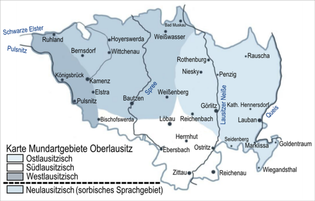
Deutsch: Karte Mundartgebiete Oberlausitz (Das Ostlausitzische schwang sich bis 1945 über die historische, am Queis gelegene Grenze zwischen der Markgrafschaft Oberlausitz und dem Herzogtum Schlesien bis nach Bunzlau) |
| Date | |
| Source | Own work |
| Author | Äberlausitzer |
Licensing edit
| I, the copyright holder of this work, release this work into the public domain. This applies worldwide. In some countries this may not be legally possible; if so: I grant anyone the right to use this work for any purpose, without any conditions, unless such conditions are required by law. |
File history
Click on a date/time to view the file as it appeared at that time.
| Date/Time | Thumbnail | Dimensions | User | Comment | |
|---|---|---|---|---|---|
| current | 17:34, 16 November 2010 | | 900 × 574 (351 KB) | Äberlausitzer (talk | contribs) | {{Information |Description={{de|1=Karte Mundartgebiete Oberlausitz}} |Source={{own}} |Author=Äberlausitzer |Date=16.11.2010 |Permission= |other_versions= }} |
You cannot overwrite this file.
File usage on Commons
There are no pages that use this file.
File usage on other wikis
The following other wikis use this file: