File:Karte Oberbergisches Eisenbahnnetz .svg

Size of this PNG preview of this SVG file: 800 × 504 pixels. Other resolutions: 320 × 202 pixels | 640 × 404 pixels | 1,024 × 646 pixels | 1,280 × 807 pixels | 2,560 × 1,614 pixels | 1,329 × 838 pixels.
Original file (SVG file, nominally 1,329 × 838 pixels, file size: 6.04 MB)
Captions
Captions
Add a one-line explanation of what this file represents
Summary edit
| Description |
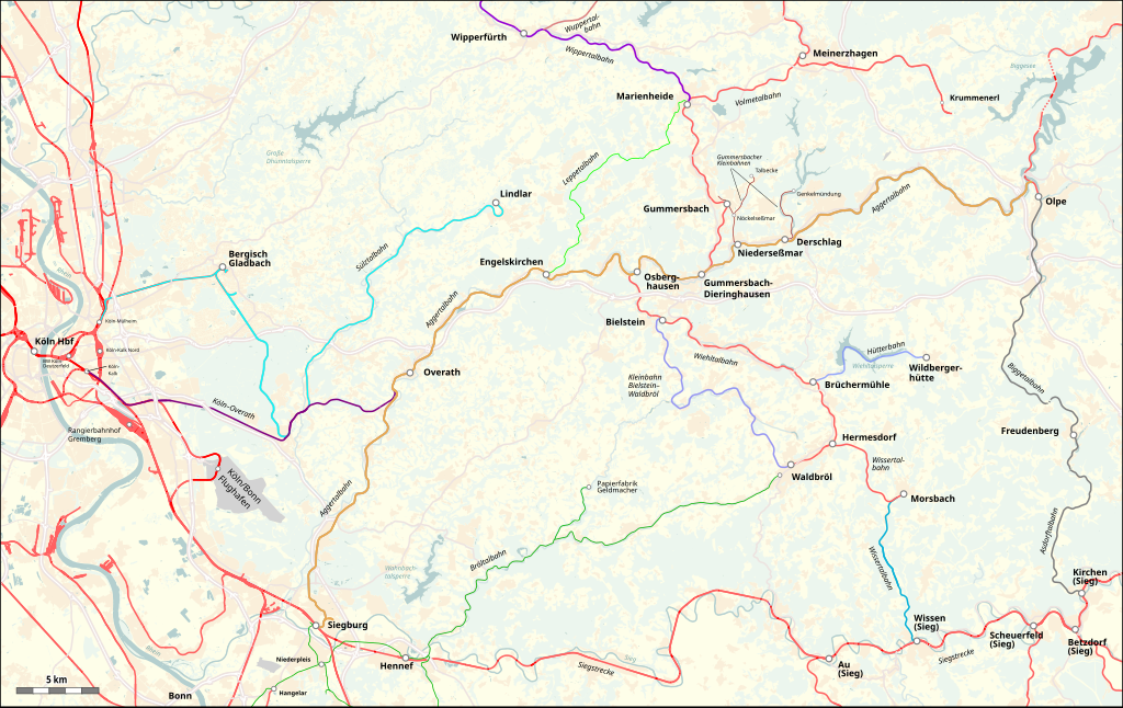
Deutsch: Oberbergisches Eisenbahnnetz |
| Date | |
| Source |
Map was created using:
|
| Creator |
|
| Permission (Reusing this file) |
Map data (c) OpenStreetMap (and) contributors, CC-BY-SA |
| Other versions |
Aggertalbahn.JPG:  |
Licensing edit
This file is licensed under the Creative Commons Attribution-Share Alike 2.0 Generic license.
Attribution: Peter Christener
- You are free:
- to share – to copy, distribute and transmit the work
- to remix – to adapt the work
- Under the following conditions:
- attribution – You must give appropriate credit, provide a link to the license, and indicate if changes were made. You may do so in any reasonable manner, but not in any way that suggests the licensor endorses you or your use.
- share alike – If you remix, transform, or build upon the material, you must distribute your contributions under the same or compatible license as the original.
| This work is licensed under the Open Database License (summary). |
File history
Click on a date/time to view the file as it appeared at that time.
| Date/Time | Thumbnail | Dimensions | User | Comment | |
|---|---|---|---|---|---|
| current | 04:54, 17 February 2020 | | 1,329 × 838 (6.04 MB) | Pechristener (talk | contribs) | devils circle seems to be gone, some add ons |
| 04:21, 17 February 2020 |  | 1,329 × 838 (6.02 MB) | Pechristener (talk | contribs) | ... fighting with a strange phenomena of the wiki renderer creating a semi circly on the map ... | |
| 16:59, 16 February 2020 |  | 1,329 × 838 (5.87 MB) | Pechristener (talk | contribs) | {{Map |description={{de|Oberbergisches Eisenbahnnetz}} |date=2020-02-16 |source=Map was created using: * [http://www.openstreetmap.org/ Open Street Map] Data |author= * Raw data: OpenStreetMap contributers * Map rendering: Pechristener using [http://maperitive.net/ Maperitive] |permission=Map data (c) OpenStreetMap (and) contributors, CC-BY-SA |other versions={{f|Aggertalbahn.JPG||250px}} |warp_status=skip }} == {{int:license-header}} == {{cc-by-sa-2.0|Peter Christe... |
You cannot overwrite this file.
File usage on Commons
The following 2 pages use this file:
File usage on other wikis
The following other wikis use this file:
- Usage on de.wikipedia.org
- Usage on www.wikidata.org