File:Karte Schloss Karlsruhe.png

Size of this preview: 785 × 599 pixels. Other resolutions: 314 × 240 pixels | 629 × 480 pixels | 1,006 × 768 pixels | 1,280 × 978 pixels | 1,955 × 1,493 pixels.
Original file (1,955 × 1,493 pixels, file size: 432 KB, MIME type: image/png)
Captions
Captions
Add a one-line explanation of what this file represents
| Description |
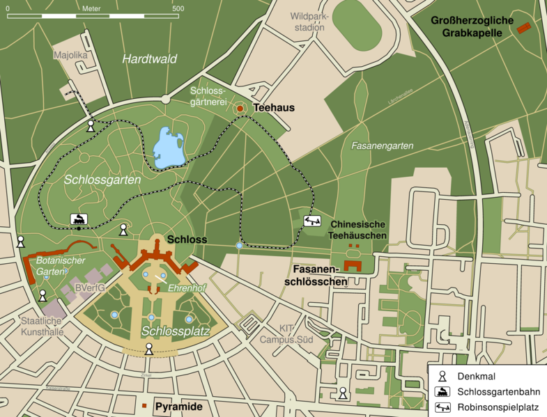
Deutsch: Karte vom Schloss Karlsruhe und den angrenzenden Gärten |
||||||||||||
| Date | |||||||||||||
| Source |
Own work using |
||||||||||||
| Author | Mmmmmicha at German Wikipedia | ||||||||||||
| Permission (Reusing this file) |
|
||||||||||||
| Other versions |
|

Original upload log edit
The original description page was here. All following user names refer to de.wikipedia.
- 2010-08-19 06:22 Mmmmmicha 2030×1567× (421954 bytes)
- 2010-08-18 23:22 Mmmmmicha 2030×1567× (422412 bytes)
- 2010-08-18 23:18 Mmmmmicha 2030×1569× (420620 bytes) Zurückgesetzt auf die Version vom 18. August 2010, 22:48 Uhr
- 2010-08-18 23:16 Mmmmmicha 2030×1569× (423347 bytes)
- 2010-08-18 22:48 Mmmmmicha 2030×1569× (420620 bytes)
- 2010-08-18 17:10 Mmmmmicha 2030×1442× (383823 bytes) == Beschreibung, Quelle == {{Information |Beschreibung = Arbeitsdatei von mmmmmicha |Quelle = * eigenes Werk * [openstreetmap.org] * [http://commons.wikimedia.org/wiki/File:MUTCD_W15-1.svg MUTCD_W15-1.svg] * [http://commons.wikimedia.org/wiki/File:1.2_roa
File history
Click on a date/time to view the file as it appeared at that time.
| Date/Time | Thumbnail | Dimensions | User | Comment | |
|---|---|---|---|---|---|
| current | 21:47, 4 September 2014 | | 1,955 × 1,493 (432 KB) | Ras67 (talk | contribs) | -bg |
| 21:35, 4 September 2014 |  | 1,955 × 1,493 (432 KB) | Ras67 (talk | contribs) | cropped | |
| 09:18, 11 April 2011 |  | 2,030 × 1,567 (412 KB) | File Upload Bot (Magnus Manske) (talk | contribs) | {{BotMoveToCommons|de.wikipedia|year={{subst:CURRENTYEAR}}|month={{subst:CURRENTMONTHNAME}}|day={{subst:CURRENTDAY}}}} {{Information |Description={{de|Arbeitsdatei von mmmmmicha<br/> == Lizenz: == [[:de:Kateg |
You cannot overwrite this file.
File usage on Commons
The following page uses this file:
File usage on other wikis
The following other wikis use this file:
- Usage on be.wikipedia.org
- Usage on de.wikipedia.org
- Usage on fr.wikipedia.org
- Usage on ru.wikipedia.org
- Usage on uk.wikipedia.org
- Usage on vi.wikipedia.org
- Usage on www.wikidata.org