File:Karte Straßenbahn der Gemeinde Steglitz.png

Size of this preview: 800 × 479 pixels. Other resolutions: 320 × 192 pixels | 640 × 383 pixels | 1,024 × 614 pixels | 1,280 × 767 pixels | 2,884 × 1,728 pixels.
Original file (2,884 × 1,728 pixels, file size: 955 KB, MIME type: image/png)
Captions
Captions
Add a one-line explanation of what this file represents

|
This transport map image could be re-created using vector graphics as an SVG file. This has several advantages; see Commons:Media for cleanup for more information. If an SVG form of this image is available, please upload it and afterwards replace this template with
{{vector version available|new image name}}.
It is recommended to name the SVG file “Karte Straßenbahn der Gemeinde Steglitz.svg”—then the template Vector version available (or Vva) does not need the new image name parameter. |
Summary edit
| Description |
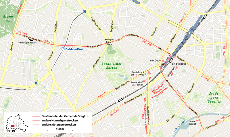
Deutsch: Karte der Straßenbahn der Gemeinde Steglitz auf heutigem Stadtgrundriss
English: Map of the Steglitz tram (Berlin) |
||||||||||||
| Date | |||||||||||||
| Source | Own work, using | ||||||||||||
| Creator | |||||||||||||
| Permission (Reusing this file) |
|
||||||||||||
| Georeferencing | If inappropriate please set warp_status = skip to hide. |

|
This map has been made or improved in the German Kartenwerkstatt (Map Lab). You can propose maps to improve as well.
|
File history
Click on a date/time to view the file as it appeared at that time.
| Date/Time | Thumbnail | Dimensions | User | Comment | |
|---|---|---|---|---|---|
| current | 16:28, 18 February 2013 | | 2,884 × 1,728 (955 KB) | NordNordWest (talk | contribs) | upd |
| 19:07, 12 February 2013 |  | 2,884 × 1,728 (956 KB) | NordNordWest (talk | contribs) | upd | |
| 20:01, 28 December 2010 |  | 2,884 × 1,728 (947 KB) | NordNordWest (talk | contribs) | c | |
| 18:10, 2 December 2010 |  | 2,884 × 1,728 (938 KB) | NordNordWest (talk | contribs) | c | |
| 09:23, 25 November 2010 |  | 2,884 × 1,728 (938 KB) | NordNordWest (talk | contribs) | corr | |
| 20:47, 24 November 2010 |  | 2,884 × 1,728 (960 KB) | NordNordWest (talk | contribs) | corr | |
| 18:50, 19 November 2010 |  | 2,884 × 1,728 (934 KB) | NordNordWest (talk | contribs) | =={{int:filedesc}}== {{Information |Description= {{de|Karte der Straßenbahn der Gemeinde Steglitz auf heutigem Stadtgrundriss}} {{en|Map of the Steglitz tram (Berlin)}} |Source={{Own}}, using |Date=2010-11-19 | |
You cannot overwrite this file.
File usage on Commons
The following page uses this file:
File usage on other wikis
The following other wikis use this file: