File:Karte Waldheide 1980er.svg

Size of this PNG preview of this SVG file: 351 × 599 pixels. Other resolutions: 141 × 240 pixels | 281 × 480 pixels | 450 × 768 pixels | 600 × 1,024 pixels | 1,201 × 2,048 pixels | 991 × 1,690 pixels.
Original file (SVG file, nominally 991 × 1,690 pixels, file size: 236 KB)
Captions
Captions
Add a one-line explanation of what this file represents
Summary edit
| Description |
|
| Date | |
| Source |
|
| Author | kjunix |
| Permission (Reusing this file) |
This map was created from OpenStreetMap project data, collected by the community. This file is licensed under the Creative Commons Attribution-Share Alike 2.0 Generic license.
|
| SVG development |
![[1]](http://www.stadtarchiv-heilbronn.de/stadtgeschichte/unterricht/bausteine/waldheide/texte/_files/Flugblatt_1988h_quer.jpg)
![[2]](http://www.usarmygermany.com/Communities/Heilbronn/Fort%20Redleg%20GY%20638%201976-77%201800.jpg)
File history
Click on a date/time to view the file as it appeared at that time.
| Date/Time | Thumbnail | Dimensions | User | Comment | |
|---|---|---|---|---|---|
| current | 10:26, 26 July 2013 | | 991 × 1,690 (236 KB) | Kjunix (talk | contribs) | fix typos |
| 10:39, 14 February 2013 |  | 991 × 1,690 (236 KB) | Kjunix (talk | contribs) | various fixes | |
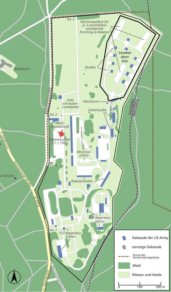
| 20:48, 30 December 2012 |  | 991 × 1,690 (234 KB) | Kjunix (talk | contribs) | == {{int:filedesc}} == {{Information| |Description = *{{de|Karte der Heilbronner Waldheide während der Pershing-II-Stationierung (um 1985).}} |Source = * base map: OpenStreetMap * [http://www.stadtarchiv-heilbronn.de/stadtgeschichte/unterricht/baustei... |
You cannot overwrite this file.
File usage on Commons
The following page uses this file: