File:Karte der Eisenbahn von Strassburg nach Basel - btv1b102238289.jpg

Size of this preview: 388 × 600 pixels. Other resolutions: 155 × 240 pixels | 310 × 480 pixels | 496 × 768 pixels | 662 × 1,024 pixels | 1,324 × 2,048 pixels | 2,643 × 4,087 pixels.
Original file (2,643 × 4,087 pixels, file size: 1.96 MB, MIME type: image/jpeg)
Captions
Captions
Add a one-line explanation of what this file represents
Summary
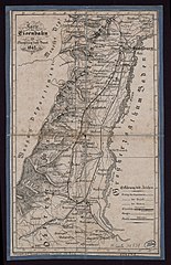
edit| Karte der Eisenbahn von Strassburg nach Basel
( |
|||||||||||||||||||||||||||
|---|---|---|---|---|---|---|---|---|---|---|---|---|---|---|---|---|---|---|---|---|---|---|---|---|---|---|---|
| Author |
Levrault, Vve. Cartographe |
||||||||||||||||||||||||||
| Title |
Karte der Eisenbahn von Strassburg nach Basel |
||||||||||||||||||||||||||
| Description |
Français : Sujet : Alsace, Province d' -- Chemins de fer -- 19e siècle
Chemins de fer -- Alsace (France) -- Cartes (19e siècle) Strasbourg-bâle, Chemin de fer (France) (19e siècle) Échelle(s) : 1:481 000 Appartient à l’ensemble documentaire : BNUStr007 Appartient à l’ensemble documentaire : BNUStras1 Langue : français français Éditeur : (Strasbourg) |
||||||||||||||||||||||||||
| Dimensions | height: 20 cm (7.8 in); width: 33 cm (12.9 in) | ||||||||||||||||||||||||||
| Collection |
|
||||||||||||||||||||||||||
| References |
Français : Notice du catalogue : http://catalogue.bnf.fr/ark:/12148/cb41909265g |
||||||||||||||||||||||||||
| Source/Photographer |
Français : Bibliothèque nationale et universitaire de Strasbourg, MCARTE10731
Bibliothèque nationale de France |
||||||||||||||||||||||||||
| Permission (Reusing this file) |
|
||||||||||||||||||||||||||

File history
Click on a date/time to view the file as it appeared at that time.
| Date/Time | Thumbnail | Dimensions | User | Comment | |
|---|---|---|---|---|---|
| current | 22:12, 23 August 2022 | | 2,643 × 4,087 (1.96 MB) | Gzen92Bot (talk | contribs) | Gallica btv1b102238289 |
You cannot overwrite this file.
File usage on Commons
The following page uses this file: