File:Karte der Norfolkinsel.png
No higher resolution available.
Karte_der_Norfolkinsel.png (330 × 354 pixels, file size: 12 KB, MIME type: image/png)
Captions
Captions
Add a one-line explanation of what this file represents
Summary edit
| Description |
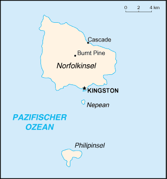
Deutsch: Karte der Norfolkinsel |
| Source | CIA World Factbook, übersetzt |
| Author | CIA |
Licensing edit
This image is in the public domain because it contains materials that originally came from the United States Central Intelligence Agency's World Factbook.
|
 |
Original upload log edit
Transferred from de.wikipedia to Commons by Nachcommonsverschieber using CommonsHelper.
The original description page was here. All following user names refer to de.wikipedia.
- 2004-12-30 12:36 Tzzzpfff 330×354× (12076 bytes) Karte der Norfolkinsel, CIA World Factbook, übersetzt {{Bild-PD}}
File history
Click on a date/time to view the file as it appeared at that time.
| Date/Time | Thumbnail | Dimensions | User | Comment | |
|---|---|---|---|---|---|
| current | 11:43, 11 July 2013 | | 330 × 354 (12 KB) | File Upload Bot (Magnus Manske) (talk | contribs) | Transfered from de.wikipedia by User:Nachcommonsverschieber using CommonsHelper |
You cannot overwrite this file.
File usage on Commons
The following 11 pages use this file:
- File:Karte de Norfolkinsel.png (file redirect)
- Category:Biota of Norfolk Island
- Category:Environment of Norfolk Island
- Category:Flora of Norfolk Island
- Category:History of Norfolk Island
- Category:Maps of Norfolk Island
- Category:Norfolk Island
- Category:Norfolk Island by decade
- Category:Norfolk Island in the 2000s
- Category:Norfolk Island in the 2010s
- Category:People of Norfolk Island
File usage on other wikis
The following other wikis use this file:
- Usage on ca.wikipedia.org
- Usage on de.wikipedia.org
- Usage on ga.wikipedia.org
- Usage on gl.wikipedia.org
- Usage on tr.wikipedia.org
- Usage on www.wikidata.org