File:Karte der Regionalstadtbahn Salzburg.png

Size of this preview: 383 × 600 pixels. Other resolutions: 153 × 240 pixels | 306 × 480 pixels | 490 × 768 pixels | 654 × 1,024 pixels | 1,307 × 2,048 pixels | 2,813 × 4,406 pixels.
Original file (2,813 × 4,406 pixels, file size: 9.97 MB, MIME type: image/png)
Captions
Captions
Add a one-line explanation of what this file represents
Summary edit
| Description |
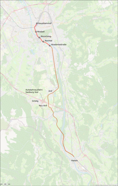
Deutsch: Karte der geplanten Regionalstadtbahn Salzburg. Die unterirdische Streckenführung des Abschnitts bis Akademiestraße (rot) wurde im Mai 2022 festgelegt, die oberirdische Streckenführung bis Hallein (braun) ist noch nicht festgelegt. Der direkte Verlauf ist als ausgezogene Linie dargestellt, die Variante über Neu-Anif und ev. Gödig ist mit Punkten dargestellt |
| Date | |
| Source |
Own work Map was created using:
Information about the route: |
| Author | |
| Permission (Reusing this file) |
Map data (c) OpenStreetMap (and) contributors, CC-BY-SA |
Licensing edit
This file is licensed under the Creative Commons Attribution-Share Alike 2.0 Generic license.
- You are free:
- to share – to copy, distribute and transmit the work
- to remix – to adapt the work
- Under the following conditions:
- attribution – You must give appropriate credit, provide a link to the license, and indicate if changes were made. You may do so in any reasonable manner, but not in any way that suggests the licensor endorses you or your use.
- share alike – If you remix, transform, or build upon the material, you must distribute your contributions under the same or compatible license as the original.
File history
Click on a date/time to view the file as it appeared at that time.
| Date/Time | Thumbnail | Dimensions | User | Comment | |
|---|---|---|---|---|---|
| current | 21:25, 7 May 2022 | | 2,813 × 4,406 (9.97 MB) | Pechristener (talk | contribs) | non-transparent background |
| 21:20, 7 May 2022 |  | 2,813 × 4,406 (10.1 MB) | Pechristener (talk | contribs) | {{Information |Description={{de|Karte der geplanten Regionalstadtbahn Salzburg. Die unterirdische Streckenführung des Abschnitts bis Akademiestraße (rot) wurde im Mai 2022 festgelegt, die oberirdische Streckenführung bis Hallein (braun) ist noch nicht festgelegt. Der direkte Verlauf ist als ausgezogene Linie dargestellt, die Variante über Neu-Anif und ev. Gödig ist mit Punkten dargestellt}} |Source ={{own}} Map was created using: *[http://www.openstreetmap.org Open Street Map] Dat... |
You cannot overwrite this file.
File usage on Commons
The following 2 pages use this file:
File usage on other wikis
The following other wikis use this file:
- Usage on de.wikipedia.org