File:Karte der Straße von Oman mit ungefährer Position zweier Öltanker am 13 Juni 2019 gegen 0800 UTC.png

Size of this preview: 800 × 586 pixels. Other resolutions: 320 × 234 pixels | 640 × 469 pixels | 894 × 655 pixels.
Original file (894 × 655 pixels, file size: 58 KB, MIME type: image/png)
Captions
Captions
Add a one-line explanation of what this file represents
Summary edit
| Description |
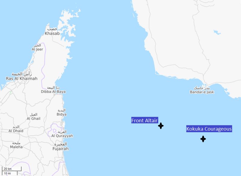
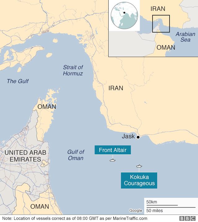
English: Map shows Gulf of Oman with approx. position of two oil tankers attacked there on June 13, 2019.
Deutsch: Die Karte zeigt die ungefähre Position zweier am 13. Juni 2013 im Golf von Oman angegriffener Öltanker. |
| Date | |
| Source |
Own work Die Position der Schiffe gegen 08:00 UTC ist abgeleitet von der grafischen Darstellung bei der BBC, https://ichef.bbci.co.uk/news/624/cpsprodpb/119A/production/_107360540_strait_of_hormuz_v3_640map-nc.png |
| Author | Matthiasb; Kartographie von OpenStreetMap-Mitwirkenden. |
Licensing edit
I, the copyright holder of this work, hereby publish it under the following license:
This file is licensed under the Creative Commons Attribution-Share Alike 4.0 International license.
- You are free:
- to share – to copy, distribute and transmit the work
- to remix – to adapt the work
- Under the following conditions:
- attribution – You must give appropriate credit, provide a link to the license, and indicate if changes were made. You may do so in any reasonable manner, but not in any way that suggests the licensor endorses you or your use.
- share alike – If you remix, transform, or build upon the material, you must distribute your contributions under the same or compatible license as the original.
File history
Click on a date/time to view the file as it appeared at that time.
| Date/Time | Thumbnail | Dimensions | User | Comment | |
|---|---|---|---|---|---|
| current | 13:31, 15 June 2019 | | 894 × 655 (58 KB) | Matthiasb (talk | contribs) | {{Information |description ={{en|1=Map shows Gulf of Oman with approx. position of two oil tankers attacked there on June 13, 2019.}} {{de|1=Die Karte zeigt die ungefähre Positin zweier am 13. Juni 2013 im Golf vn Oman angegriffener Öltanker. Die Position der Schiffe gegen 08:00 UTC ist abgeleitet von der grafishen Darstellung bei der BBC, https://ichef.bbci.co.uk/news/624/cpsprodpb/119A/production/_107360540_strait_of_hormuz_v3_640map-nc.png}} |date =2019-06-15 |source ={{o... |
You cannot overwrite this file.
File usage on Commons
There are no pages that use this file.
File usage on other wikis
The following other wikis use this file:
- Usage on de.wikipedia.org
- Usage on de.wikinews.org