File:Karte der Vereinigten Herzogtümer Jülich-Kleve-Berg (1540).png

Size of this preview: 557 × 599 pixels. Other resolutions: 223 × 240 pixels | 446 × 480 pixels | 823 × 885 pixels.
Original file (823 × 885 pixels, file size: 297 KB, MIME type: image/png)
Captions
Captions
Add a one-line explanation of what this file represents
Summary edit
.png&action=edit§ion=1)
| Description |
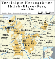
Deutsch: Karte der Vereinigten Herzogtümer Jülich-Kleve-Berg um 1540.
English: Map of the United Duchies of Jülich-Cleve-Berg in 1540. |
| Date | |
| Source | Own work/Source of Information: Putzger – Historischer Weltatlas, 89. Auflage, 1965; Westermanns Großer Atlas zur Weltgeschichte, 1969; Haacks geographischer Atlas. VEB Hermann Haack Geographisch-Kartographische Anstalt, Gotha/Leipzig, 1. Auflage, 1979; dtv-Atlas zur Weltgeschichte 1. Von den Anfängen bis zur Französischen Revolution; 23. Aufl. 1989, ISBN 3-423-03001-1. |
| Author | Ziegelbrenner. |

|
This map has been made or improved in the German Kartenwerkstatt (Map Lab). You can propose maps to improve as well.
|
Licensing edit
.png&action=edit§ion=2)
I, the copyright holder of this work, hereby publish it under the following licenses:

|
Permission is granted to copy, distribute and/or modify this document under the terms of the GNU Free Documentation License, Version 1.2 or any later version published by the Free Software Foundation; with no Invariant Sections, no Front-Cover Texts, and no Back-Cover Texts. A copy of the license is included in the section entitled GNU Free Documentation License. |
This file is licensed under the Creative Commons Attribution-Share Alike 3.0 Unported, 2.5 Generic, 2.0 Generic and 1.0 Generic license.
- You are free:
- to share – to copy, distribute and transmit the work
- to remix – to adapt the work
- Under the following conditions:
- attribution – You must give appropriate credit, provide a link to the license, and indicate if changes were made. You may do so in any reasonable manner, but not in any way that suggests the licensor endorses you or your use.
- share alike – If you remix, transform, or build upon the material, you must distribute your contributions under the same or compatible license as the original.
You may select the license of your choice.
File history
Click on a date/time to view the file as it appeared at that time.
| Date/Time | Thumbnail | Dimensions | User | Comment | |
|---|---|---|---|---|---|
| current | 13:53, 3 April 2019 | | 823 × 885 (297 KB) | Ziegelbrenner (talk | contribs) | + Meer |
| 13:46, 3 April 2019 |  | 823 × 885 (297 KB) | Ziegelbrenner (talk | contribs) | + Vest Recklinghausen | |
| 21:23, 21 October 2013 |  | 823 × 886 (2.09 MB) | Hans Erren (talk | contribs) | Heinsberg zu Jülich seit 1484. | |
| 19:27, 6 May 2011 |  | 823 × 886 (384 KB) | Spazzo (talk | contribs) | {{Information |Description={{de|Karte der Vereinigten Herzogtümer Jülich-Kleve-Berg um 1540.}} {{en|Map of the {{w|United Duchies of Jülich-Cleve-Berg}} in 1540.}} |Source=*File:Karte_der_Vereinigten_Herzogtümer_Jülich-Kleve-Berg_(1540).png |Da | |
| 17:08, 6 December 2010 |  | 823 × 886 (335 KB) | Ziegelbrenner (talk | contribs) | 2011-12-06 | |
| 10:48, 2 November 2010 |  | 827 × 886 (422 KB) | Ziegelbrenner (talk | contribs) | 2010-11-02 | |
| 09:15, 14 October 2010 |  | 827 × 886 (423 KB) | Ziegelbrenner (talk | contribs) | 2010-10-14 | |
| 13:28, 4 October 2010 |  | 827 × 886 (419 KB) | Ziegelbrenner (talk | contribs) | 2010-10-04 | |
| 10:17, 27 September 2010 |  | 827 × 886 (402 KB) | Ziegelbrenner (talk | contribs) | 2010-09-27 | |
| 12:37, 7 July 2010 |  | 824 × 671 (246 KB) | Ziegelbrenner (talk | contribs) | {{Information |Description={{en|1=Map of the United Duchies of Jülich-Kleve-Berg}} {{de|1=Karte der Vereinigten Herzogtümer Jülich-Kleve-Berg}} |Source=xaca |Author=dsada |Date=2010-07-07 |Permission=ffds |other_versions=unknown }} [[Category:Maps of |
.png)
You cannot overwrite this file.
File usage on Commons
The following 2 pages use this file:
- File:Herzogtümer Jülich-Kleve-Van Den Bergh(en) 1540.png (file redirect)
- File:Vereinigten Herzogtümer-J-K-B.png (file redirect)
_1540.png&redirect=no)
File usage on other wikis
The following other wikis use this file:
- Usage on ar.wikipedia.org
- Usage on bg.wikipedia.org
- Usage on br.wikipedia.org
- Usage on ca.wikipedia.org
- Usage on cs.wikipedia.org
- Usage on de.wikipedia.org
- 1539
- Grafschaft Mark
- Herzogtum Geldern
- Herzogtum Kleve
- Geschichte des Ruhrgebiets
- Herzogtum Jülich
- Vereinigte Herzogtümer Jülich-Kleve-Berg
- Grafschaft Ravensberg
- Herzogtum Berg
- Dritter Geldrischer Erbfolgekrieg
- Geschichte Nordrhein-Westfalens
- Wikipedia:Kartenwerkstatt/Archiv/2010-12
- Benutzer:Ziegelbrenner/Meine Bilder auf Commons
- Chronologie der Geschichte von Rees
- Usage on en.wikipedia.org
- Usage on eo.wikipedia.org
- Usage on es.wikipedia.org
- Usage on et.wikipedia.org
- Usage on he.wikipedia.org
- Usage on ja.wikipedia.org
- Usage on ka.wikipedia.org
- Usage on nl.wikipedia.org
- Usage on pl.wikipedia.org
- Usage on pt.wikipedia.org
- Usage on ro.wikipedia.org
- Usage on ru.wikipedia.org
View more global usage of this file.
.png)
.png&oldid=476017425)