File:Karwendel Karte Hugo Petters.TIF

Original file (3,774 × 3,252 pixels, file size: 5.51 MB, MIME type: image/tiff)
Captions
Captions
Summary
edit| DescriptionKarwendel Karte Hugo Petters.TIF |
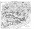
English: Map of Karwendel, Tyrol, Austria. By Hugo Petters, based on Maps by DAV and OeAV (Deutscher Alpenverein, Österreichischer Alpenverein), published in: Heinrich Schwaiger: Schwaiger's Führer durch das Karwendelgebirge. J. Lindauersche Buchandlung, München 1907
Deutsch: Karte des Karwendelgebirges, Tirol. Von Hugo Pettersauf Basis von Karten des DAV and OeAV (Deutscher Alpenverein, Österreichischer Alpenverein) gezeichnet, veröfentlicht in: Heinrich Schwaiger: Schwaiger's Führer durch das Karwendelgebirge. J. Lindauersche Buchandlung, München 1907 |
||||||||||||||||||||||
| Date | |||||||||||||||||||||||
| Source | Heinrich Schwaiger: Schwaiger's Führer durch das Karwendelgebirge | ||||||||||||||||||||||
| Author |
creator QS:P170,Q18508308 |
||||||||||||||||||||||
| Other versions |
 |
||||||||||||||||||||||
Licensing
edit| Public domainPublic domainfalsefalse |
|
This work is in the public domain in its country of origin and other countries and areas where the copyright term is the author's life plus 70 years or fewer. Note that a few countries have copyright terms longer than 70 years: Mexico has 100 years, Jamaica has 95 years, Colombia has 80 years, and Guatemala and Samoa have 75 years. This image may not be in the public domain in these countries, which moreover do not implement the rule of the shorter term. Honduras has a general copyright term of 75 years, but it does implement the rule of the shorter term. Copyright may extend on works created by French who died for France in World War II (more information), Russians who served in the Eastern Front of World War II (known as the Great Patriotic War in Russia) and posthumously rehabilitated victims of Soviet repressions (more information).
| |
| This file has been identified as being free of known restrictions under copyright law, including all related and neighboring rights. | |
https://creativecommons.org/publicdomain/mark/1.0/PDMCreative Commons Public Domain Mark 1.0falsefalse
File history
Click on a date/time to view the file as it appeared at that time.
| Date/Time | Thumbnail | Dimensions | User | Comment | |
|---|---|---|---|---|---|
| current | 13:05, 25 September 2011 |  | 3,774 × 3,252 (5.51 MB) | McZusatz (talk | contribs) | thumb fix |
| 12:49, 25 September 2011 |  | 12,172 × 10,490 (4.61 MB) | McZusatz (talk | contribs) | thumb fix | |
| 10:43, 9 November 2009 |  | 12,172 × 10,490 (4.57 MB) | Svíčková (talk | contribs) | {{Information |Description={{en|1=Map of Karwendel, Tyrol, Austria. By Hugo Petters, based on Maps by DAV and OeAV (Deutscher Alpenverein, Österreichischer Alpenverein), published in: Heinrich Schwaiger: Schwaiger's Führer durch |
You cannot overwrite this file.
File usage on Commons
The following page uses this file:
Metadata
This file contains additional information such as Exif metadata which may have been added by the digital camera, scanner, or software program used to create or digitize it. If the file has been modified from its original state, some details such as the timestamp may not fully reflect those of the original file. The timestamp is only as accurate as the clock in the camera, and it may be completely wrong.
| Width | 3,774 px |
|---|---|
| Height | 3,252 px |
| Bits per component | 8 |
| Compression scheme | Deflate (PKZIP) |
| Pixel composition | Black and white (Black is 0) |
| Orientation | Normal |
| Number of components | 1 |
| Number of rows per strip | 64 |
| Horizontal resolution | 400 dpi |
| Vertical resolution | 400 dpi |
| Data arrangement | chunky format |