File:Kasvillisuus.png
Size of this preview: 800 × 423 pixels. Other resolutions: 320 × 169 pixels | 640 × 338 pixels | 1,425 × 753 pixels.
Original file (1,425 × 753 pixels, file size: 93 KB, MIME type: image/png)
Captions
Captions
Add a one-line explanation of what this file represents
Summary
edit
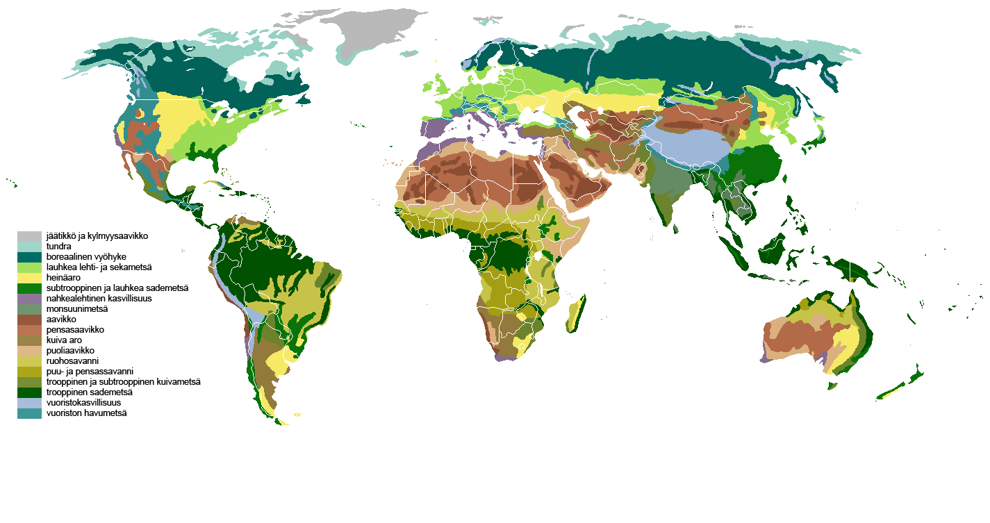
| Description | The main biomes in the world. Drawn by hand using maps. Legend in Finnish. |
| Date | |
| Source | the blank world map in Commons and WSOY Iso karttakirja for the information |
| Author | Ville Koistinen (user Vzb83) |
| Other versions | Image:Vegetation.png (in English) |

|
This biogeographical map image could be re-created using vector graphics as an SVG file. This has several advantages; see Commons:Media for cleanup for more information. If an SVG form of this image is available, please upload it and afterwards replace this template with
{{vector version available|new image name}}.
It is recommended to name the SVG file “Kasvillisuus.svg”—then the template Vector version available (or Vva) does not need the new image name parameter. |
Licensing
edit
I, the copyright holder of this work, hereby publish it under the following licenses:

|
Permission is granted to copy, distribute and/or modify this document under the terms of the GNU Free Documentation License, Version 1.2 or any later version published by the Free Software Foundation; with no Invariant Sections, no Front-Cover Texts, and no Back-Cover Texts. A copy of the license is included in the section entitled GNU Free Documentation License. |
| This file is licensed under the Creative Commons Attribution-Share Alike 3.0 Unported license. | ||
| ||
| This licensing tag was added to this file as part of the GFDL licensing update. |
This file is licensed under the Creative Commons Attribution-Share Alike 2.5 Generic, 2.0 Generic and 1.0 Generic license.
- You are free:
- to share – to copy, distribute and transmit the work
- to remix – to adapt the work
- Under the following conditions:
- attribution – You must give appropriate credit, provide a link to the license, and indicate if changes were made. You may do so in any reasonable manner, but not in any way that suggests the licensor endorses you or your use.
- share alike – If you remix, transform, or build upon the material, you must distribute your contributions under the same or compatible license as the original.
You may select the license of your choice.
File history
Click on a date/time to view the file as it appeared at that time.
| Date/Time | Thumbnail | Dimensions | User | Comment | |
|---|---|---|---|---|---|
| current | 03:04, 9 July 2011 | | 1,425 × 753 (93 KB) | Maphobbyist (talk | contribs) | Retouch |
| 02:52, 9 July 2011 |  | 1,425 × 753 (93 KB) | Maphobbyist (talk | contribs) | South Sudan has become independent on July 9, 2011. Sudan and South Sudan are shown with the new international border between them. | |
| 19:14, 9 October 2010 |  | 1,425 × 753 (93 KB) | Maphobbyist (talk | contribs) | Corrections | |
| 23:00, 21 February 2007 |  | 1,425 × 625 (73 KB) | Vzb83~commonswiki (talk | contribs) | update | |
| 11:11, 21 February 2007 |  | 1,425 × 625 (72 KB) | Vzb83~commonswiki (talk | contribs) | updated version | |
| 23:21, 20 February 2007 |  | 1,425 × 625 (72 KB) | Vzb83~commonswiki (talk | contribs) | {{Information |Description=The main biomes in the world. Drawn by hand using maps. Legend in Finnish – I'll try to translate an English version as well. |Source=the blank world map in Commons and ''WSOY Iso karttakirja'' for the information |Date=Februa |
You cannot overwrite this file.
File usage on Commons
There are no pages that use this file.
File usage on other wikis
The following other wikis use this file:
- Usage on fi.wikipedia.org
- Usage on fi.wikibooks.org