File:Katia 2011-09-01 1145Z.jpg

Size of this preview: 800 × 450 pixels. Other resolutions: 320 × 180 pixels | 640 × 360 pixels | 1,024 × 576 pixels | 1,280 × 720 pixels | 2,500 × 1,406 pixels.
Original file (2,500 × 1,406 pixels, file size: 2.37 MB, MIME type: image/jpeg)
Captions
Captions
Add a one-line explanation of what this file represents
Summary edit
| Description |
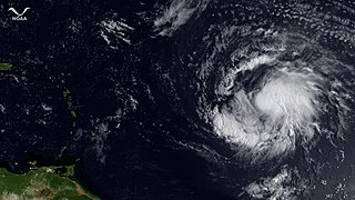
English: Hurricane Katia is on a west-northwest course about 1065 miles east of the Leeward Islands with maximum sustained winds around 75 mph. Though Katia has changed little in strength over the past several hours, the outlook from the National Hurricane Center shows the storm possibly intensifying to winds of 120 mph over the next 4 days. This GOES-13 satellite image was captured at 1145z on September 1, 2011. |
| Date | |
| Source | https://www.nnvl.noaa.gov/MediaDetail2.php?MediaID=825&MediaTypeID=1 |
| Author | NOAA |
Licensing edit
This image is in the public domain because it contains materials that originally came from the U.S. National Oceanic and Atmospheric Administration, taken or made as part of an employee's official duties.
|
File history
Click on a date/time to view the file as it appeared at that time.
| Date/Time | Thumbnail | Dimensions | User | Comment | |
|---|---|---|---|---|---|
| current | 13:48, 15 April 2018 | | 2,500 × 1,406 (2.37 MB) | A1Cafel (talk | contribs) | User created page with UploadWizard |
You cannot overwrite this file.
File usage on Commons
The following page uses this file: