File:Katyn massacres 1940 map-fr.svg

Size of this PNG preview of this SVG file: 765 × 599 pixels. Other resolutions: 306 × 240 pixels | 613 × 480 pixels | 980 × 768 pixels | 1,280 × 1,003 pixels | 2,560 × 2,006 pixels | 1,053 × 825 pixels.
Original file (SVG file, nominally 1,053 × 825 pixels, file size: 194 KB)
Captions
Captions
Add a one-line explanation of what this file represents
Summary edit
| Description |
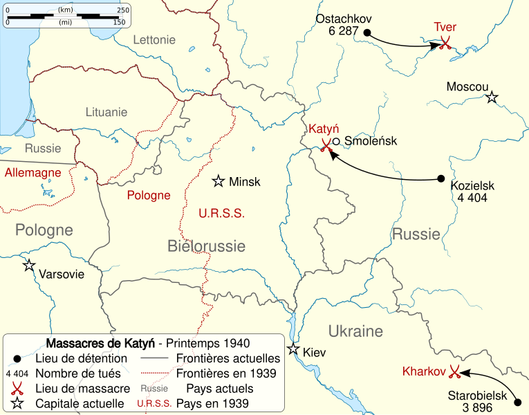
English: Map of the Katyn massacres (in the widest sense) during 1940 spring. Français : Carte des massacres de Katyń (au sens large) durant le printemps 1940. |
||
| Date | (UTC) | ||
| Source | |||
| Author |
|
||
| Other versions |
| ||
| Attribution (required by the license) | © Sémhur / Wikimedia Commons / | ||
| SVG | W3C-validity not checked.
|
||
| Graphic Lab |


| Camera location | | View this and other nearby images on: OpenStreetMap |
|---|
Licensing edit
I, the copyright holder of this work, hereby publish it under the following licenses:
| Copyleft: This work of art is free; you can redistribute it and/or modify it according to terms of the Free Art License. You will find a specimen of this license on the Copyleft Attitude site as well as on other sites. |
This file is licensed under the Creative Commons Attribution-Share Alike 4.0 International, 3.0 Unported, 2.5 Generic, 2.0 Generic and 1.0 Generic license.
- You are free:
- to share – to copy, distribute and transmit the work
- to remix – to adapt the work
- Under the following conditions:
- attribution – You must give appropriate credit, provide a link to the license, and indicate if changes were made. You may do so in any reasonable manner, but not in any way that suggests the licensor endorses you or your use.
- share alike – If you remix, transform, or build upon the material, you must distribute your contributions under the same or compatible license as the original.
You may select the license of your choice.
Original upload log edit
This image is a derivative work of the following images:
- File:2010_Polish_Air_Force_Tu-154_crash_map-pl.svg licensed with Cc-by-sa-3.0,2.5,2.0,1.0, GFDL
- 2010-04-11T21:04:47Z Vearthy 1000x567 (927970 Bytes) corrected a mistake
- 2010-04-11T20:51:31Z Vearthy 1000x567 (1217330 Bytes) added Mińsk
- 2010-04-10T23:05:29Z Mareklug 1000x567 (1216090 Bytes) {{pl|Trajektoria lotu samolotu prezydenckiego Lecha Kaczyńskiego 10 kwietnia 2010}} {{en|Flight trajectory of the Polish presidential aircraft that crashed on 10 April 2010}}
- File:Rzeczpospolita_1939.svg licensed with Cc-by-sa-3.0-migrated, GFDL
- 2008-03-14T08:54:39Z Halibutt 2014x1567 (546314 Bytes) Names of larger towns enlarged
- 2008-03-14T08:45:09Z Halibutt 2014x1567 (545740 Bytes) version corrected by Madman
- 2008-03-14T00:30:03Z Halibutt 2000x1534 (523895 Bytes) {{Information |Description= |Source=self-made |Date= |Author= [[User:Halibutt|Halibutt]] |Permission= |other_versions= }}
- 2008-03-13T23:54:06Z Halibutt 2000x1534 (561518 Bytes) {{Information |Description= |Source=self-made |Date= |Author= [[User:Halibutt|Halibutt]] |Permission= |other_versions= }}
- 2008-03-13T23:51:47Z Halibutt 2000x1534 (563352 Bytes) {{Information |Description= |Source=self-made |Date= |Author= [[User:Halibutt|Halibutt]] |Permission= |other_versions= }}
- 2008-03-13T22:28:53Z Halibutt 2000x1534 (562219 Bytes) Reverted to version as of 22:19, 13 March 2008
- 2008-03-13T22:28:36Z Halibutt 2000x1534 (562222 Bytes) {{Information |Description= |Source=self-made |Date= |Author= [[User:Halibutt|Halibutt]] |Permission= |other_versions= }}
- 2008-03-13T22:19:26Z Halibutt 2000x1534 (562219 Bytes)
- 2008-03-13T20:42:11Z Halibutt 2000x1534 (561232 Bytes)
- 2008-03-13T16:32:42Z Halibutt 2000x1534 (423502 Bytes)
- 2008-03-13T16:03:51Z Halibutt 2000x1534 (447423 Bytes)
- 2008-03-13T12:10:50Z Halibutt 2000x1534 (436427 Bytes)
- 2008-03-13T11:28:03Z Halibutt 2000x1534 (432791 Bytes)
- 2008-03-13T11:03:25Z Halibutt 2000x1534 (410253 Bytes) {{Information |Description=Test version of a vectorized [[:Image:Rzeczpospolita 1920.png]]; more changes will follow, only checking if wiki displays it right |Source=self-made |Date=2008-03-11 |Author= [[User:Halibutt|Halibut
Uploaded with derivativeFX
File history
Click on a date/time to view the file as it appeared at that time.
| Date/Time | Thumbnail | Dimensions | User | Comment | |
|---|---|---|---|---|---|
| current | 07:24, 27 May 2014 | | 1,053 × 825 (194 KB) | Sémhur (talk | contribs) | Valid SVG |
| 14:06, 26 April 2010 |  | 1,053 × 825 (194 KB) | Sémhur (talk | contribs) | {{Information |Description={{Multilingual description |en= Map of the Katyn massacres (in the widest sense) during 1940 spring. |fr= Carte des massacres de Katyń (au sens large) durant le printemps 1940. |
You cannot overwrite this file.
File usage on Commons
The following 2 pages use this file:
File usage on other wikis
The following other wikis use this file:
- Usage on fr.wikipedia.org