File:Kavir National Park 01.jpg

Size of this preview: 800 × 533 pixels. Other resolutions: 320 × 213 pixels | 640 × 427 pixels | 1,024 × 683 pixels | 1,280 × 853 pixels | 2,560 × 1,707 pixels | 4,000 × 2,667 pixels.
Original file (4,000 × 2,667 pixels, file size: 5.73 MB, MIME type: image/jpeg)
Captions
Captions
Add a one-line explanation of what this file represents
Summary
edit
| Description |
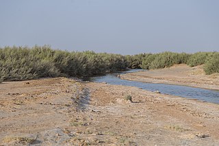
English: Kavir National Park is a protected ecological zone in northern Iran. It has an area of 4,000 square kilometers. The park is located 120 kilometers south of Tehran and 100 kilometers east of Qom, and it sits on the western end of one of Iran's two major deserts, the Dasht-e Kavir. Siahkuh, a large, semi-circular rock outcropping sits in roughly the park's center.
Deutsch: Der Kawir-Nationalpark ist ein 4.000 Quadratkilometer großes Naturschutzgebiet am westlichen Rand der Kawir-Wüste, 120 km südlich von Teheran und 100 km östlich von Qom.
Svenska: Kavir nationalpark är ett naturskyddsområde i Iran som ligger cirka 120 km söder om Teheran. Den har även status som biosfärreservat och är ungefär 440 000 hektar stor.
Русский: Национальный парк Кевир— национальный парк и один из девяти биосферных заповедников в Иране.
Italiano: Il parco nazionale di Kavir è una zona ecologica protetta dell'Iran settentrionale. Occupa un'area di 4000 km². Si trova 120 km a sud di Teheran e 100 km a est di Qom, ed è situato nell'angolo occidentale di uno dei due maggiori deserti dell'Iran, il Dasht-e Kavir.
Español: El parque nacional Kavir es un área esteparia árida y desértica iraní protegida, al igual que otros muchos lugares, desde mediados de la década de 1970.3 Situada a unos 100 km al sureste de Teherán, limita al noroeste con el desierto salado de Kavir.
हिन्दी: काविर राष्ट्रीय उद्यान उत्तरी ईरान में एक संरक्षित पारिस्थितिक क्षेत्र है।
Português: O Parque Nacional de Kavir eé uma área estepe árida e desértica no centro do Irão, na região do planalto iraniano.
فارسی: پارک ملی کویر یکی از بزرگترین و قدیمیترین مناطق حفاظتشده ایران است که بیشتر آن شهرستان گرمسار استان سمنان و بخشهای کوچکی هم در استانهای تهران، قم و اصفهان قرار میگیرد. |
| Date | |
| Source | Own work |
| Author | Mostafameraji |
| Camera location | | View this and other nearby images on: OpenStreetMap |
|---|
Licensing
edit
I, the copyright holder of this work, hereby publish it under the following license:
| This file is made available under the Creative Commons CC0 1.0 Universal Public Domain Dedication. | |
| The person who associated a work with this deed has dedicated the work to the public domain by waiving all of their rights to the work worldwide under copyright law, including all related and neighboring rights, to the extent allowed by law. You can copy, modify, distribute and perform the work, even for commercial purposes, all without asking permission.
|
File history
Click on a date/time to view the file as it appeared at that time.
| Date/Time | Thumbnail | Dimensions | User | Comment | |
|---|---|---|---|---|---|
| current | 19:23, 23 August 2020 | | 4,000 × 2,667 (5.73 MB) | Mostafameraji (talk | contribs) | Uploaded own work with UploadWizard |
You cannot overwrite this file.
File usage on Commons
There are no pages that use this file.