File:Kelenken holotype site.png
No higher resolution available.
Kelenken_holotype_site.png (255 × 362 pixels, file size: 47 KB, MIME type: image/png)
Captions
Captions
Add a one-line explanation of what this file represents
Summary
edit
| Description |
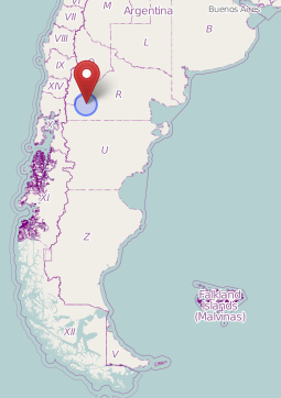
English: Map showing the approximate location (near the village Comallo) where the holotype of Kelenken was found. Nederlands: Kaart waarop bij benadering de vindplaats (in de buurt van het dorpje Comallo) van het holotype van Kelenken te zien is. |
| Date | |
| Source | OpenStreetMap ([1]) |
| Author | OpenStreetMap users |
Licensing
edit
| This work contains information from OpenStreetMap, which is made available under the Open Database License (ODbL).
The ODbL does not require any particular license for maps produced from ODbL data. Prior to 1 August 2020, map tiles produced by the OpenStreetMap Foundation were licensed under the CC-BY-SA-2.0 license. Maps produced by other people may be subject to other licences. |
File history
Click on a date/time to view the file as it appeared at that time.
| Date/Time | Thumbnail | Dimensions | User | Comment | |
|---|---|---|---|---|---|
| current | 19:16, 11 February 2022 | | 255 × 362 (47 KB) | FunkMonk (talk | contribs) | Cropped unnecessary top. |
| 18:16, 27 May 2013 |  | 255 × 534 (49 KB) | Amphicoelias (talk | contribs) | User created page with UploadWizard |
You cannot overwrite this file.
File usage on Commons
The following page uses this file:
File usage on other wikis
The following other wikis use this file:
- Usage on ar.wikipedia.org
- Usage on cs.wikipedia.org
- Usage on fr.wikipedia.org
- Usage on he.wikipedia.org
- Usage on hu.wikipedia.org
- Usage on id.wikipedia.org
- Usage on ja.wikipedia.org
- Usage on nl.wikipedia.org
- Usage on pt.wikipedia.org
- Usage on www.wikidata.org
- Usage on zh.wikipedia.org